Approximate Location Map
Large Map »
Latitude: 52.9231 / 52°55'23"N
Longitude: -4.1216 / 4°7'17"W
OS Eastings: 257467
OS Northings: 338294
OS Grid: SH574382
Mapcode National: GBR 5Q.MTGV
Mapcode Global: WH55L.NSJG
Plus Code: 9C4QWVFH+69
Entry Name: The Cob (partly in Penrhyndeudraeth)
Listing Date: 22 February 1991
Last Amended: 26 September 2005
Grade: II*
Source: Cadw
Source ID: 85406
ID on this website: 300085406
Location: Embankment across the S end of Traeth Mawr, on the E side of porthmadog harbour and town.
County: Gwynedd
Town: Porthmadog
Community: Porthmadog
Community: Porthmadog
Locality: Ynys Tywyn
Built-Up Area: Porthmadog
Traditional County: Caernarfonshire
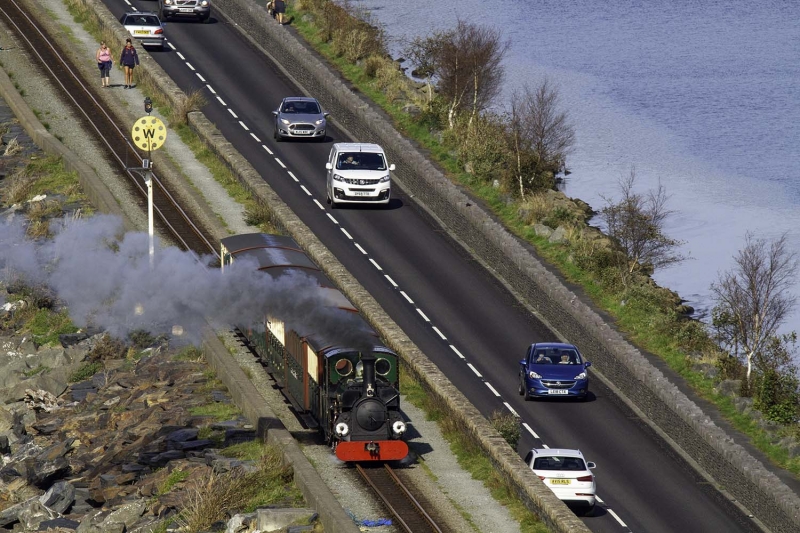
The Great Embankment or Cob was conceived by William Madocks MP and built in 1808-11 under the supervision of Madocks' agent John Williams. It was an ambitious successor to an embankment of 1800 higher up the estuary and the difficulties that occurred during construction make this one of the most dramatic achievements in early C19 transport history. The need for this crossing was linked to Madocks' creation of Tremadog and his plans for a postal route to Ireland via Porthdinllaen in the Lleyn peninsula. Its other function was to reclaim agricultural land on the W bank of the Afon Glaslyn. Madocks relied principally upon his own knowledge to design the embankment, but various professionals, including John Loudon, were briefly involved. Barracks were built at both ends (Ynys Tywyn and Boston Lodge) to accommodate the large workforce. The major problem in construction was that the force of the tide and the river was so great that the stones were washed away almost as soon as they were laid; another difficulty was that the course of the river was not diverted until after construction. The embankment was opened in July 1811 and had cost approximately £60,000; it quickly became a major attraction for artists and tourists. A severe storm in 1812 breached the embankment and major repairs had to be undertaken despite tremendous financial difficulties.
In 1836 the lower Cob was added on the inland side to carry the new road while the original embankment was converted to carry the new Ffestiniog narrow-gauge railway - a slate transporting line from Blaenau Ffestiniog to Porthmadog, constructed 1832-6. The railway was closed in 1946 but now operates again as a tourist line.
A substantial rubble-built embankment approximately 1.5 km long, consisting of a lower (road) section and a higher (rail) section. The higher part of the embankment is approximately 6m tall with single-track railway and flanking footpath. The later and much lower 1836 embankment has a narrow double carriageway. The seaward (S) side is heavily buttressed by boulders gradually sloping down to the water. The buttressing on the (N) landward side is less substantial and is predominantly a grassed bank. Parapets are of rubble slate-stone, approximately 0.5m to 1m high (except to the seaward side where it is concrete). The parapet between roadway and cycle track is of stone from Dyffryn Nantlle, replacing a wall of stone from Blaenau Ffestiniog. Masonry breaks and changes in the coping indicated that the wall between the higher and lower sections has been heavily repaired. At the Porthmadog end the parapet of the higher embankment terminates opposite No 6 Tros Y Bont and beside the curve into the railway station. On both sides of the higher embankment at the E end are steps down to the shore and the road. Beyond, the railway tracks curve NE or continue into the Boston Lodge Workshops. Beneath the curve is a semicircular arched recess, now blocked but originally serving as a passage beneath the railway. It has a portal-like entrance with coursed masonry and voussoirs. At the Boston Lodge end the Cob terminates at the gated steps between the railway line and the road.
Listed Grade II* for its special interest as a major historic engineering achievement associated firstly with the reclamation of Traeth Mawr and, later, with the construction of the Ffestiniog Railway, giving The Cob a major place in the history of Porthmadog and North Wales.
External links are from the relevant listing authority and, where applicable, Wikidata. Wikidata IDs may be related buildings as well as this specific building. If you want to add or update a link, you will need to do so by editing the Wikidata entry.


Other nearby listed buildings
