Approximate Location Map
Large Map »
Latitude: 51.9441 / 51°56'38"N
Longitude: -3.3846 / 3°23'4"W
OS Eastings: 304926
OS Northings: 228198
OS Grid: SO049281
Mapcode National: GBR YP.MP3X
Mapcode Global: VH6BZ.9D2G
Plus Code: 9C3RWJV8+M5
Entry Name: 81, The Watton, Brecon
Listing Date: 4 November 2005
Last Amended: 4 November 2005
Grade: II
Source: Cadw
Source ID: 85795
Building Class: Domestic
ID on this website: 300085795
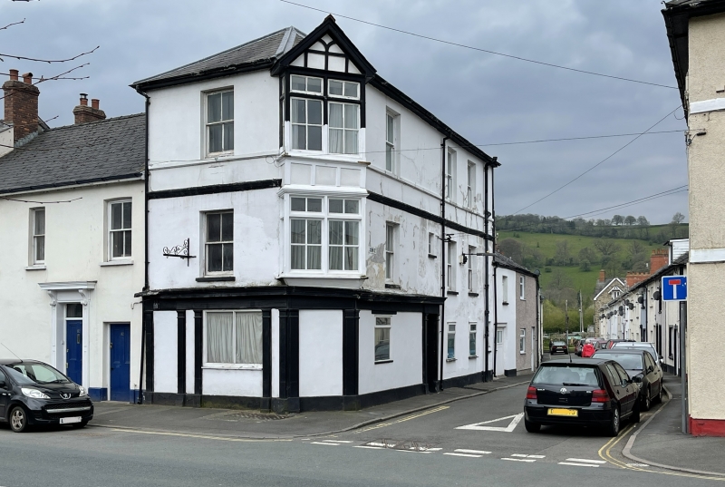
Location: On corner with John Street.
County: Powys
Town: Brecon
Community: Brecon (Aberhonddu)
Community: Brecon
Built-Up Area: Brecon
Traditional County: Brecknockshire
Tagged with: Building
Mid-to-late C19; corner oriel early C20.
Three storey building. Stucco, with bands; hipped slate roof. Single bay to The Watton with 4-pane hornless sash window on first and second floors. Three window front to John Street with 4-pane sashes on first and second floors (horned on second floor). Corner bay has 2-storey rectangular oriel with gable and applied timber framing. On ground floor, former shop or public house front to both elevations; articulated by pilasters; fascia and cornice; blocked doorway to The Watton; blocked corner doorway; doorway in John Street. Modern glazing on ground floor.
Included for Group Value with adjacent listed buildings in The Watton.
External links are from the relevant listing authority and, where applicable, Wikidata. Wikidata IDs may be related buildings as well as this specific building. If you want to add or update a link, you will need to do so by editing the Wikidata entry.


Other nearby listed buildings
