Approximate Location Map
Large Map »
Latitude: 51.0048 / 51°0'17"N
Longitude: -2.192 / 2°11'31"W
OS Eastings: 386626
OS Northings: 122846
OS Grid: ST866228
Mapcode National: GBR 1XH.YDG
Mapcode Global: FRA 669G.7W2
Plus Code: 9C3V2R35+W6
Entry Name: Mile Post Outside No 56
Listing Date: 15 October 1973
Grade: II
Source: Historic England
Source ID: 1240035
English Heritage Legacy ID: 438123
ID on this website: 101240035
Location: Shaftesbury, Dorset, SP7
County: Dorset
Civil Parish: Shaftesbury
Built-Up Area: Shaftesbury
Traditional County: Dorset
Lieutenancy Area (Ceremonial County): Dorset
Church of England Parish: Shaftesbury St Peter
Church of England Diocese: Salisbury
Tagged with: Milestone
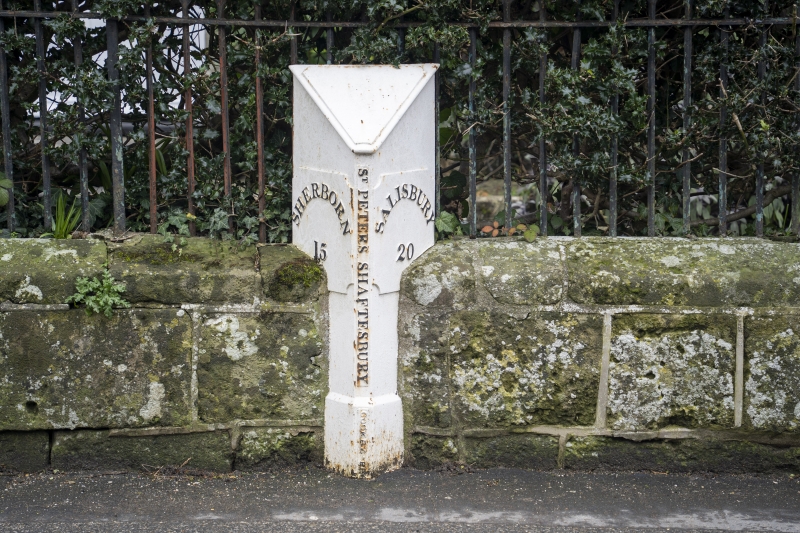
1.
1615 SALISBURY STREET
(North-East side)
Mile Post outside
No 56
ST 8622 7/292
II
2.
Early to mid C19, Triangular shaped mile post of cast iron; panelled sides;
downward pointing apex over iwu+row central band. Bears the following inscrip-
tions; in left hand panel, "Sherborn 15"; in right hand panel "Salisbury
20" and in central panel the words " St Peters " Shaftesbury."
Listing NGR: ST8662622845
External links are from the relevant listing authority and, where applicable, Wikidata. Wikidata IDs may be related buildings as well as this specific building. If you want to add or update a link, you will need to do so by editing the Wikidata entry.


Other nearby listed buildings
