Approximate Location Map
Large Map »
Latitude: 50.7298 / 50°43'47"N
Longitude: -1.1624 / 1°9'44"W
OS Eastings: 459211
OS Northings: 92581
OS Grid: SZ592925
Mapcode National: GBR 9CN.0YD
Mapcode Global: FRA 87G4.T4L
Plus Code: 9C2WPRHQ+W2
Entry Name: 27 and 28, Cross Street
Listing Date: 18 May 1972
Grade: II
Source: Historic England
Source ID: 1276044
English Heritage Legacy ID: 410556
ID on this website: 101276044
Location: Ryde, Isle of Wight, PO33
County: Isle of Wight
Civil Parish: Ryde
Built-Up Area: Ryde
Traditional County: Hampshire
Lieutenancy Area (Ceremonial County): Isle of Wight
Church of England Parish: Ryde
Church of England Diocese: Portsmouth
Tagged with: Building
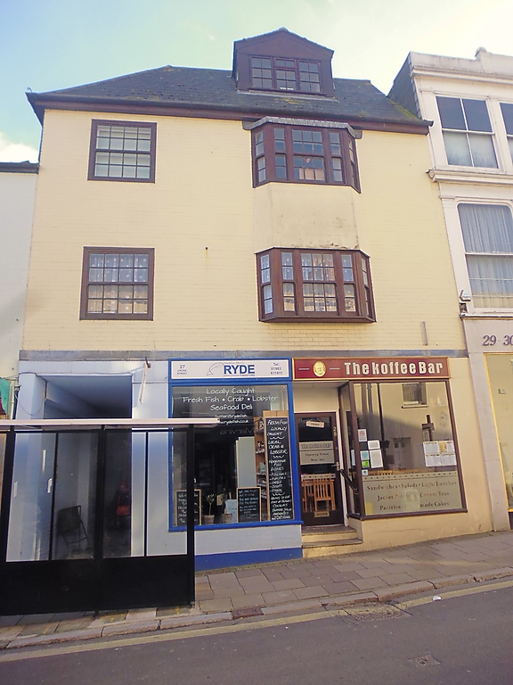
CROSS STREET
1.
1577
(South Side)
Nos 27 & 28
SZ 5992 2/62
II GV
2.
No 27 adjoins No 24, as the intervening numbers are at the back
in an alley. One building. Two storeys, three windows. Painted
brick. One bay window in centre of the first floor and tall
narrow windows flanking it. Glazing bars intact above ground
floor. Modern shop fronts.
Nos 23, 24, 27 and No 28 form a group.
Listing NGR: SZ5921192581
External links are from the relevant listing authority and, where applicable, Wikidata. Wikidata IDs may be related buildings as well as this specific building. If you want to add or update a link, you will need to do so by editing the Wikidata entry.


Other nearby listed buildings
