Approximate Location Map
Large Map »
Latitude: 53.3706 / 53°22'14"N
Longitude: -2.9985 / 2°59'54"W
OS Eastings: 333658
OS Northings: 386433
OS Grid: SJ336864
Mapcode National: GBR 7YHG.MG
Mapcode Global: WH87D.XJ9X
Plus Code: 9C5V92C2+6H
Entry Name: Numbers 16 and 17 with Gatepiers to Street
Listing Date: 13 March 1973
Grade: II
Source: Historic England
Source ID: 1282516
English Heritage Legacy ID: 389319
ID on this website: 101282516
Location: Rock Park, Wirral, Merseyside, CH42
County: Wirral
Electoral Ward/Division: Rock Ferry
Parish: Non Civil Parish
Built-Up Area: Birkenhead
Traditional County: Cheshire
Lieutenancy Area (Ceremonial County): Merseyside
Church of England Parish: Rock Ferry St Peter
Church of England Diocese: Chester
Tagged with: Building
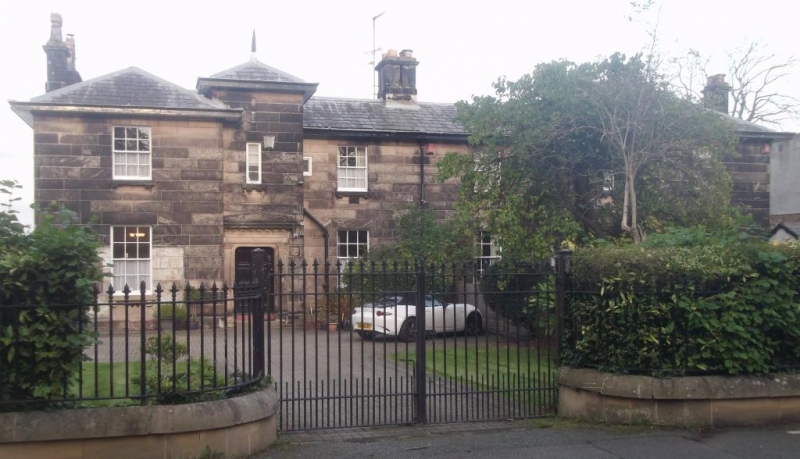
BIRKENHEAD
SJ3386 ROCK PARK, Rock Ferry
789-1/12/259 (East side)
13/03/73 Nos.16 AND 17
with gatepiers to street
GV II
Pair of houses. c1836. Ashlar-faced with Welsh slate roof.
Neo-classical style, 2 storeys, each house a 3-window range
double-pile plan symmetrically-designed with outer hipped
gabled wings. Each house has central entrance in full-height
pyramidal roofed porch to angle formed by wing. 6-panelled
door in moulded stone architrave with narrow window over.
12-pane sashes flank this on each floor, the lower window to
the right in 16 cut by added lean-to verandah. Overhanging
eaves, end wall stacks. Rear elevation follows similar
configuration with outer hipped gabled wings with canted bays
to ground floor, and a balcony carried on cast-iron columns
and stone brackets with ornate wrought iron railings across
the central range. Paired gate piers to street front with
recessed panels and shallow pyramidal caps. The house forms
part of the original Rock Park development laid out in 1836 by
J.Bennison.
(The Buildings of England: Pevsner N and Hubbard E: Cheshire:
Harmondsworth: 1971-).
Listing NGR: SJ3365886433
External links are from the relevant listing authority and, where applicable, Wikidata. Wikidata IDs may be related buildings as well as this specific building. If you want to add or update a link, you will need to do so by editing the Wikidata entry.


Other nearby listed buildings
