Approximate Location Map
Large Map »
Latitude: 54.5417 / 54°32'30"N
Longitude: -1.9227 / 1°55'21"W
OS Eastings: 405101
OS Northings: 516270
OS Grid: NZ051162
Mapcode National: GBR HH0X.KQ
Mapcode Global: WHB4L.F3PM
Plus Code: 9C6WG3RG+MW
Entry Name: Monkhouse and Coupland Tombs Approximately 5 Metres East of Church of St Mary
Listing Date: 28 November 1994
Grade: II
Source: Historic England
Source ID: 1282732
English Heritage Legacy ID: 388791
ID on this website: 101282732
Location: St Mary's Church, Startforth, County Durham, DL12
County: County Durham
Civil Parish: Barnard Castle
Built-Up Area: Barnard Castle
Traditional County: Durham
Lieutenancy Area (Ceremonial County): County Durham
Church of England Parish: Barnard Castle with Whorlton
Church of England Diocese: Durham
Tagged with: Tomb
BARNARD CASTLE
NZ0516SW NEWGATE
770-1/6/162 (South side (off))
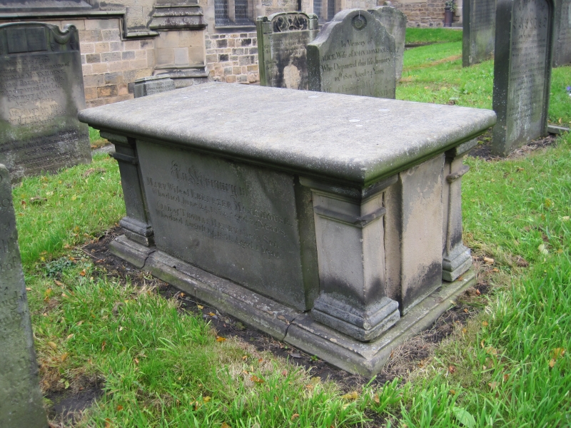
Monkhouse and Coupland tombs
approximately 5 metres east of
Church of St Mary
GV II
Group of chest tomb and 3 headstones approx 5m east of
chancel.
Chest: c1832 to Mary, wife of Ebenezer Monkhouse, d.1832 aged
34, and Henry their son d.1831 aged one. Also Ebenezer, carpet
manufacturer formerly of Barnard Castle, d.1865 at Stewineke,
Nova Scotia. Tuscan angle pilasters and plain stone sides
support round-edged top; inscriptions in long panels on north
and south.
Headstone approx 0.3m. to north: early C19; to Alice, wife of
John Monkhouse, d.1801 aged 24, and Francis wife of John
d.1808; stone slab approx one metre high with shaped top and
carved oval patera.
Headstone approx 1.5m to west: to Thomas Monkhouse d.1817 aged
67, and his family d.1782 and 1814; stone slab about one metre
high with open book with drapery in shaped head.
Headstone approx 0.5 metres to south: to John the third son of
John Coupland, d.February 10th 1737 aged 2; stone slab approx
0.5m high with rounded top and raised margin.
Listing NGR: NZ0510116270
External links are from the relevant listing authority and, where applicable, Wikidata. Wikidata IDs may be related buildings as well as this specific building. If you want to add or update a link, you will need to do so by editing the Wikidata entry.


Other nearby listed buildings
