Approximate Location Map
Large Map »
Latitude: 52.3313 / 52°19'52"N
Longitude: -2.7109 / 2°42'39"W
OS Eastings: 351652
OS Northings: 270599
OS Grid: SO516705
Mapcode National: GBR BL.V792
Mapcode Global: VH849.YNQN
Plus Code: 9C4V87JQ+GJ
Entry Name: Old Yew Tree Farmhouse
Listing Date: 15 March 1974
Grade: II
Source: Historic England
Source ID: 1383616
English Heritage Legacy ID: 484048
ID on this website: 101383616
Location: Ashford Bowdler, Shropshire, SY8
County: Shropshire
Civil Parish: Ashford Bowdler
Traditional County: Shropshire
Lieutenancy Area (Ceremonial County): Shropshire
Church of England Parish: Ashford Bowdler
Church of England Diocese: Hereford
Tagged with: Farmhouse
ASHFORD BOWDLER
SO5170 Old Yew Tree Farmhouse
482-1/14/22
15/03/74
GV II
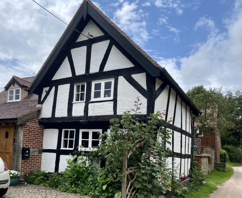
Farmhouse now house. C17 front range, early C18 main range,
C20 extension. Painted timber-frame with painted brick infill
on painted stone plinth, brick to rear; brick main range;
plain-tiled roofs. Brick coped gables to rear with projecting
gable-end chimneys. Front range of 2 framed bays aligned
east-west with single-bay cross wing to rear. Parallel main
range of 2 units set back to right.
EXTERIOR: front range of 2 storeys with side wall-frame to
road (north) of square framing 3 panels high with straight
braces each side. Left return gable-end: jettied first floor
with rectangular panels on plain bressumer, and straight
braces; 2 C20 casements; gable-end truss of straight tie beam,
twin raking struts, and collar; square framing 2 panels deep
to ground floor, 2 C20 casements. Rear wing to left (east):
brick, single-storey and attic; entrance door in enclosed C20
lean-to porch extension, tiled gabled dormer with 2-light
casement. Rear wing gable-end (south): C19 casement at attic
flanked by pigeon holes with ledges built into gable end;
brick storey band; C19 4-light casement in enlarged brick
segmentally-arched opening at ground level. Main range of 2
storeys and undercroft. Rear garden (south) facade: C20
casement window with top lights to ground-floor left; with 2
C20 casements connected under flat dormer roof with brickwork
between as continuation of main wall projecting through
original eaves. Street (north) facade with 2 single-light
casements, plain boarded door to undercroft. C20 entrance
porch to left.
INTERIOR: front range with deep-chamfered bridging beams, roof
with twin-strut internal truss, single trenched purlin roof.
Rear wing with twin raking-strut truss and single purlin roof.
Main range with chamfered bridging beam with ogee-chamfer
stops, roof with framed internal partition and truss with tie
beam, vertical struts, collar and twin raking struts, single
purlin roof.
Listing NGR: SO5165270599
External links are from the relevant listing authority and, where applicable, Wikidata. Wikidata IDs may be related buildings as well as this specific building. If you want to add or update a link, you will need to do so by editing the Wikidata entry.


Other nearby listed buildings
