Approximate Location Map
Large Map »
Latitude: 51.653 / 51°39'10"N
Longitude: -3.1953 / 3°11'42"W
OS Eastings: 317406
OS Northings: 195592
OS Grid: ST174955
Mapcode National: GBR HX.72YZ
Mapcode Global: VH6DF.KQN4
Plus Code: 9C3RMR33+6V
Entry Name: Penllwyn, former manor house now Penllwyn Arms public house
Listing Date: 25 May 1962
Last Amended: 31 March 1999
Grade: II*
Source: Cadw
Source ID: 1881
Building Class: Commercial
Also known as: Penllwyn Arms
Penllwyn Arms, Blackwood
ID on this website: 300001881
Location: On the hillside W of the town centre, in an open space but surrounded by Penllwyn estate development.
County: Caerphilly
Community: Pontllanfraith (Pontllan-fraith)
Community: Pontllanfraith
Locality: Penllwyn
Built-Up Area: Pontllan-fraith
Traditional County: Monmouthshire
Tagged with: Pub
C16. Seat of the Morgan family. Built together with Rhos Newydd by Thomas Morgan of Machen for youngest son Edmund. Thomas Morgan fought with the Earl of Richmond at the Battle of Bosworth 1485 and was granted as reward land of the parishes of Bedwellty and Mynyddislwyn. Bradney provides family tree of Morgan family at Penllwyn Sarph, showing many members holding high office, as sheriffs, MPs, judges . Became part of Llanover Estate in 1757 when Florence Morgan conveyed estate to her husband John Jones of Llanarth. Archdeacon Coxe on his travels c 1800 reported two portraits of members of the family killed in 1670 in a duel with Charles Williams of Caerleon. Former use as convent, subsequently a welfare clinic. Also formerly known as Penllwyn Sarph and shown on first edition OS map as Penllwyn Fawr and surrounded then by garden and orchard. Sketch of rear of E-shaped wing made in 1953 is included in Bradney 1993 edition.
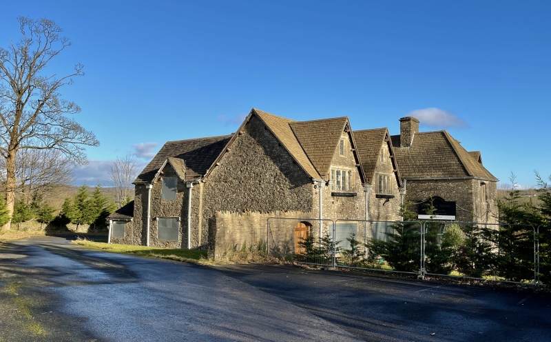
Manor House. A long rectangular building of rubble with ashlar dressings and stone tile roof: large ridge stack over porch bay and twin angled stacks end right with cornices; further stacks to rear. 2 storeys and attic. 5 bays, the centre a 2-storeyed hipped roof porch. Windows have diamond mullions with ashlar surrounds, metal-framed casements with quarry glazing; some of the armatures to which the leaded lights were originally attached are still in situ. Windows to left wing have hoodmoulds, those to right have relieving arches. Central porch has 2-light window to first floor; below is the main entrance with 4-centred arch, rough voussoirs and surround; set back boarded door with grille and decorative hinges; 3-light side window; battered and with boulder footings. To left each bay has a narrow steep-pitched gable with sprocketed eaves, a single rectangular light to attic; 4-light window to first floor and 5 to ground floor. To right the gabled bays are similar though wider with 2-light windows to attic, paired double-light windows to first floor and 3-light to ground floor, with doorways to left side of each bay, square headed and deep set to right under relieiving arch now the main entrance to public house (blocked window to right) and segmental arched to left; signs of alterations to some openings . Downhill-facing gable end is a rebuild or extension with the twin stacks astride the gable and uniform small mullioned windows under relieving arches, 2 to each floor. Large external stack adjacent also with twin gabled stacks. Flat roofed extension to rear masks main building but the variation in roof pitches shows a division between the two wings and the irregular E-shaped plan of the N wing. This comprises 3 steeply gabled wings of unequal depths, that to left incorporating a stepped stack, the centre rendered with an attic light, to right a slightly lower wing with a narrower bay stepped down to rear. Seen from the side, the wing has a half dormer with windows similar to front and a further pitched roof extending over outshut from the rear bay. Extending from front left a is a short stretch of wall incorporating an archway.
Interior mostly remodelled during various occupations with fireplaces blocked. Ground floor consists of two main large rooms each extending across both bays. Stairs, replaced, rise to rear to large first floor room with chamber over porch. Main roof structure has pegged A-frame trusses with carpenters' marks, partly visible in first floor rooms.
Listed II* as a major C16 and later manor house; group value with the surrounding wall.
External links are from the relevant listing authority and, where applicable, Wikidata. Wikidata IDs may be related buildings as well as this specific building. If you want to add or update a link, you will need to do so by editing the Wikidata entry.


Other nearby listed buildings
