History in Structure

Garden Wall at Penllwyn

A Grade II Listed Building in Pontllanfraith, Caerphilly

More Photos »
Approximate Location Map
Large Map »

Coordinates

Latitude: 51.6529 / 51°39'10"N

Longitude: -3.1958 / 3°11'44"W

OS Eastings: 317371

OS Northings: 195573

OS Grid: ST173955

Mapcode National: GBR HX.72VR

Mapcode Global: VH6DF.KQD9

Plus Code: 9C3RMR33+4M

Entry Name: Garden Wall at Penllwyn

Listing Date: 31 March 1999

Last Amended: 31 March 1999

Grade: II

Source: Cadw

Source ID: 21630

Building Class: Domestic

ID on this website: 300021630

Location: Surrounds the former Manor, the front section incorporating a gateway.

County: Caerphilly

Community: Pontllanfraith (Pontllan-fraith)

Community: Pontllanfraith

Locality: Penllwyn

Built-Up Area: Pontllan-fraith

Traditional County: Monmouthshire

Tagged with: Wall

Find accommodation in
Mynyddislwyn

History

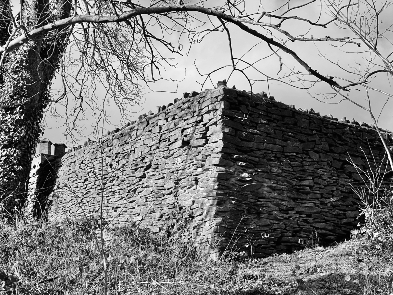
The garden enclosure is probably C16 and contemporary with the building. Shows as at present on Tithe Map 1846 but with two buildings adjacent at SW either side of current gap. On first edition OS map the wall surrounds a garden and orchard.

Exterior

Rubble wall with rough stone coping surrounding the former garden of the former manor house. Highest area is to front where the wall is stepped out to form an entrance bay roughly reflecting the frontage and raised to form piers to a segmental arched pegged boarded gate with heavy hinges. The wall continues down and across the hillside and to rear where it is interupted by a breeze block recess, and continues along uphill side to W where there is a wide entrance opening.

Reasons for Listing

Included for its historic interest as delineating the former garden enclosure and for group value with the the manor house.

External Links

External links are from the relevant listing authority and, where applicable, Wikidata. Wikidata IDs may be related buildings as well as this specific building. If you want to add or update a link, you will need to do so by editing the Wikidata entry.

Recommended Books

Other nearby listed buildings

  • II* Penllwyn, former manor house now Penllwyn Arms public house
    On the hillside W of the town centre, in an open space but surrounded by Penllwyn estate development.
  • II Former Mynyddislwyn Urban District Council Offices
    In the centre of Pontllanfraith, facing the site of the former railway station and dismantled railway; standing on a walled and railed terrace a little above the roadway with steps to right and vehicu
  • II Shangri-la
    Towards W of the community, on a corner site with Hill Road, set in a sloping garden.
  • II War Memorial
    Sited in a small terraced enclosure in open ground in front of Caerphilly Borough Council Offices.
  • II Siloh Presbyterian Church
    In the small hamlet of Gelli-groes, on a side street N of the main Newport Road, set back from the road within a small walled graveyard with houses close on each side.
  • II Pair of chest tombs at Siloh Presbyterian Church
    Close to the front wall of the chapel in the small graveyard fronting the road.
  • II Heather Cottage
    In the centre of the small hamlet of Gelli-groes, on a side road leading off the main Newport Road and almost opposite Siloh chapel.
  • II* Gelli-groes Mill
    Reached by a side road running SE from Newport Road (A4048); the Mill faces the Sirhowy River and the bridge and is within a grassy enclosure which retains sluices, channelled millrace and tail race,

BritishListedBuildings.co.uk is an independent online resource and is not associated with any government department. All government data published here is used under licence. Please do not contact BritishListedBuildings.co.uk for any queries related to any individual listed building, planning permission related to listed buildings or the listing process itself.

British Listed Buildings is a Good Stuff website.