Approximate Location Map
Large Map »
Latitude: 53.3445 / 53°20'40"N
Longitude: -4.566 / 4°33'57"W
OS Eastings: 229279
OS Northings: 386135
OS Grid: SH292861
Mapcode National: GBR HM3V.TG7
Mapcode Global: WH429.T6XC
Plus Code: 9C5Q8CVM+QJ
Entry Name: Trefadog
Listing Date: 5 April 1971
Last Amended: 16 February 2001
Grade: II
Source: Cadw
Source ID: 5305
Building Class: Domestic
ID on this website: 300005305
Location: In an isolated location by the coast, at the end of a country lane, c2kms SW of Llanfaethlu and 2kms NNW of Llanfwrog.
County: Isle of Anglesey
Town: Holyhead
Community: Llanfaethlu
Community: Llanfaethlu
Locality: Porth Trefadog
Traditional County: Anglesey
Tagged with: Farmhouse
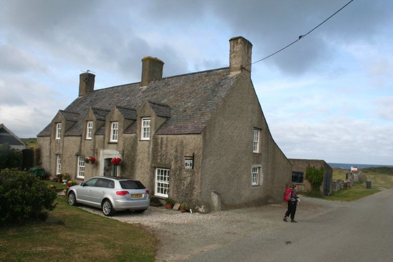
Trefadog is an important sub-medieval house, one of few on the island, and the only known example of full cruck construction on Anglesey. It was also a rare example of the use of decorative timber roof construction, with decorative windbracing to an ornate open roof (indicative of its origins as an open hall house), but this work was lost in the later C20. The exterior form of the house owes its character to C18 remodelling. Formerly part of the C19 estate of Lord Stanley of Alderley, recorded in the tithe schedule of 1840.
Sub medieval farmhouse with later Georgian detail. A 2-storey, 4-window range with single storey addition to NW corner. Cross passage plan with doorway offset to R (N), 2 bays to left of entrance, 1 to right; unaligned upper and lower windows. Built of stone, pebbledash rendered. Modern slate roof with slate ridge; tall rendered stacks, gable stacks and one ridge stack to L (S) of door. Gabled half dormers at 1st floor; 4 along front (E) entrance elevation, 2 to rear (at S end). Recessed hornless sash windows, ground floor 16-pane, 1st floor 9-pane, all with slate sills. Addition with modern casements.
The interior of the house was stripped prior to the current ownership (1980s), but the house still retains the original cross passage plan and the large cambered bressumer over the inglenook fireplace; as well as one of the original full crucks.
Listed as an important sub-medieval house retaining early form and plan, and with some early detail including one cruck truss (notwithstanding loss of original open roof).
External links are from the relevant listing authority and, where applicable, Wikidata. Wikidata IDs may be related buildings as well as this specific building. If you want to add or update a link, you will need to do so by editing the Wikidata entry.


Other nearby listed buildings
