Approximate Location Map
Large Map »
Latitude: 52.0156 / 52°0'56"N
Longitude: -4.8355 / 4°50'7"W
OS Eastings: 205517
OS Northings: 239038
OS Grid: SN055390
Mapcode National: GBR CR.H38P
Mapcode Global: VH2MZ.4LHP
Plus Code: 9C4Q2587+6Q
Entry Name: Westleigh
Listing Date: 14 April 1992
Last Amended: 31 August 1993
Grade: II
Source: Cadw
Source ID: 13082
Building Class: Domestic
ID on this website: 300013082
Location: Situated in terraced row at W end of Upper West Street.
County: Pembrokeshire
Community: Newport (Trefdraeth)
Community: Newport
Built-Up Area: Newport
Traditional County: Pembrokeshire
Tagged with: Building
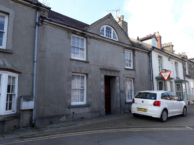
Early C19 house with later unpainted stucco facing, slate roof and large stone end stacks. Two and a half storeys, double-fronted with central pedimental gable and nogged brick to gable eaves. Gable has tripartite lunette window with glazing bars, main floors have two 12-pane hornless sashes with slate sills, centre 6-panel door with 4 fielded panels and traceried overlight. Earlier outbuilding to rear.
Raised stucco angle piers, vermiculated rusticated ground floor surrounds, labels to first floor windows and arch with keystone to lunette.
Pediment with lunette appears on several late C18 to early C19 buildings in the Cardigan-Fishguard region, possibly associated with a single builder. In Newport, Cromlech House and former Rectory have similar features.
.
Group value with adjoining listed items
External links are from the relevant listing authority and, where applicable, Wikidata. Wikidata IDs may be related buildings as well as this specific building. If you want to add or update a link, you will need to do so by editing the Wikidata entry.


Other nearby listed buildings
