Approximate Location Map
Large Map »
Latitude: 51.5049 / 51°30'17"N
Longitude: -3.0878 / 3°5'16"W
OS Eastings: 324596
OS Northings: 179002
OS Grid: ST245790
Mapcode National: GBR J2.JD05
Mapcode Global: VH7BQ.FFGP
Plus Code: 9C3RGW36+XV
Entry Name: Ty-du and adjoining byre and stable
Listing Date: 19 May 1975
Last Amended: 20 July 2000
Grade: II
Source: Cadw
Source ID: 13822
Building Class: Domestic
ID on this website: 300013822
Location: On the levels, facing the main thoroughfare from which it is separated by a small reen; very near the SE community boundary.
County: Cardiff
Town: Cardiff
Community: Trowbridge
Community: Trowbridge
Locality: Wentloog Level
Built-Up Area: Cardiff
Traditional County: Monmouthshire
Tagged with: Farmhouse
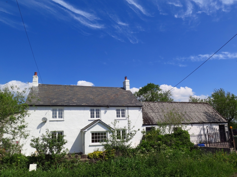
Originally a small probably C17 unit later extended, probably in C18/early C19, when the axis of the building was altered through a right angle. Formerly thatched and roof raised since 1935. Called Ty Ddu on Tithe Map.
Farmhouse and former byre and stable. Mostly of stone rubble clad in roughcast with Welsh slate roof and end stacks; attached range is limewashed with corrugated roof. 2 storeys, 3 window slightly asymmetrical range of 6/6 pane casements; ground floor has central gabled porch entered from side. Attached to front right is a wall extending along the bank of the reen. Attached to rear is a single storey 3-bay slate-roofed storage range; lean-to to left. Farm range to right has 2 doorways, one with stable door, and a window adjacent to house with 3 small ventilation slits at eaves level; one rear doorway and cambered headed boarded opening.
Wide central hall with older unit leading off to right; former open fireplace with stairs to right converted to cupboard, cross beams chamfered and stopped.
Listed as a traditional small regional farmhouse retaining its character.
External links are from the relevant listing authority and, where applicable, Wikidata. Wikidata IDs may be related buildings as well as this specific building. If you want to add or update a link, you will need to do so by editing the Wikidata entry.


Other nearby listed buildings
