Approximate Location Map
Large Map »
Latitude: 51.5057 / 51°30'20"N
Longitude: -3.1081 / 3°6'29"W
OS Eastings: 323187
OS Northings: 179114
OS Grid: ST231791
Mapcode National: GBR J1.J6XD
Mapcode Global: VH7BQ.2FQ2
Plus Code: 9C3RGV4R+7Q
Entry Name: Longcross Farm
Listing Date: 19 May 1975
Last Amended: 20 July 2000
Grade: II
Source: Cadw
Source ID: 13823
Building Class: Domestic
ID on this website: 300013823
Location: Wentloog Road has been blocked off and absorbed into an as yet (Spring 2000) undeveloped industrial estate; farmhouse is reached through an estate road via a security barrier off Wentloog Avenue.
County: Cardiff
Town: Cardiff
Community: Trowbridge
Community: Trowbridge
Locality: Wentloog Level
Built-Up Area: Cardiff
Traditional County: Monmouthshire
Tagged with: Farmhouse
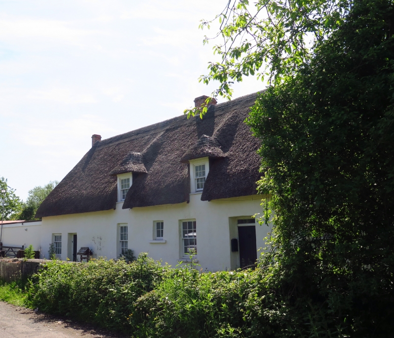
Mid C17 later extended along same axis. Appears as Llancross on Tithe map.
Long farmhouse. Of lime-rendered stone rubble with thatched roof and brick end and ridge stacks. Single storey and attic. Original unit to right (W) has 3 dormers with thatched gabled roofs, boarded surrounds and 12-pane sashes; 3 similar larger windows to ground floor with doorway centre right which has boarded door and overlight; additional small (staircase) window between the two windows to left. Later though contiguous wing to left, division marked by a stone pier attached to front wall, has separate door and sash window and flat-roofed extension. Battered.
Older unit to right retains fireplace with bressumer and old bread oven, stone stairs beside and large chamfered and stopped cross beam. Partition divides off an inner room to right with boxed-in beam. A-frame roof reported as surviving with 2 rows of purlins.
Listed as a regional farmhouse unusually retaining a thatched roof as well as its C17 core.
External links are from the relevant listing authority and, where applicable, Wikidata. Wikidata IDs may be related buildings as well as this specific building. If you want to add or update a link, you will need to do so by editing the Wikidata entry.


Other nearby listed buildings
