History in Structure

Turnpike House

A Grade II Listed Building in Llanllechid, Gwynedd

More Photos »
Approximate Location Map
Large Map »

Coordinates

Latitude: 53.2189 / 53°13'8"N

Longitude: -4.0695 / 4°4'10"W

OS Eastings: 261917

OS Northings: 371092

OS Grid: SH619710

Mapcode National: GBR 5S.17XM

Mapcode Global: WH548.GCC5

Plus Code: 9C5Q6W9J+H5

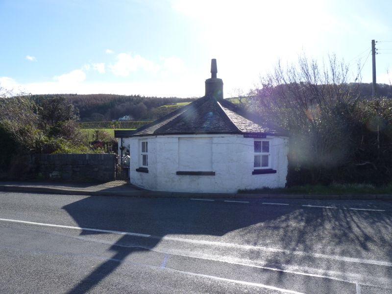
Entry Name: Turnpike House

Listing Date: 9 March 2000

Last Amended: 9 March 2000

Grade: II

Source: Cadw

Source ID: 22937

Building Class: Domestic

ID on this website: 300022937

Location: Located right on road in Tan-y-lon at junction between the old Bangor to Conwy road and the road which runs roughly parallel with it between Tan-y-lon and Eglwys St Cross.

County: Gwynedd

Town: Bangor

Community: Llanllechid

Community: Llanllechid

Locality: Tan-y-lon

Traditional County: Caernarfonshire

Tagged with: House

Find accommodation in
Llanllechid

History

Constructed as a toll house on the Bangor to Conway road, which was turnpiked as part of the route between Chester and Holyhead in the 1820s.

Exterior

Single-storey pentagonal building with splayed end to road. Painted regularly coursed rubblestone blocks; graded slate roof. Splayed end has C20 windows in original openings with slate cills to sides and blind panel to centre for former toll board; roughcast ridge stack near splayed end. Entrance in left return through C20 glazed door; C20 flat-roofed addition also on this side. Painted board to eaves on splayed end with pointing hand reads "LLANLLECHID 2 1/2".

Interior

Interior not accessible at time of Survey.

Reasons for Listing

Included, notwithstanding late C20 windows and extension, as an essentially well-preserved toll keeper's cottage on the former turnpike road.

External Links

External links are from the relevant listing authority and, where applicable, Wikidata. Wikidata IDs may be related buildings as well as this specific building. If you want to add or update a link, you will need to do so by editing the Wikidata entry.

Recommended Books

Other nearby listed buildings

  • II Tan-y-lon
    Located on the north-west side of the road at Tan-y-lon; rubblestone wall to front with slate-on-edge coping and iron pedestrian gates.
  • II Tan-y-lon
    Located on the south side of the road a little to the west of the other buildings at Tan-y-lon; modern timber fencing to front gardens on roadside and slate fencing to side boundaries.
  • II* Farmbuildings at Ty'n-yr-hendre
    Situated around 4 sides of an excellently preserved cobbled yard below and to the north-west of the former farmhouse at Ty'n-yr-hendre.
  • II* Shelter Shed/Pigsties at Ty'n-yr-hendre
    Located in the middle of the cobbled farmyard at Ty'n-yr-hendre.
  • II Ty'n-yr-hendre
    Located off east side of minor road climbing south-eastwards off the A 55 towards Bronydd Isaf; the former farmhouse is situated on rising ground approximately 70m from the nearest part of the farmbui
  • II Plas Hwfa
    Situated in undulating pasture field landscape, the farmhouse is reached from the track running southwards off the road between Eglwys St Cross and Tan-y-lon to Tal-y-bont-uchaf, which now continues v
  • II U-shaped Range of Farmbuildings at Tal-y-bont-uchaf
    Situated on the north-east side of the cobbled farmyard at Tal-y-bont uchaf.
  • II Tal-y-bont-uchaf and attached farmbuildings
    Situated in undulating pasture field landscape, the farmhouse is reached from the track running southwards off the road between Eglwys St Cross and Tan-y-lon; farmbuildings attached and adjoinining ar

BritishListedBuildings.co.uk is an independent online resource and is not associated with any government department. All government data published here is used under licence. Please do not contact BritishListedBuildings.co.uk for any queries related to any individual listed building, planning permission related to listed buildings or the listing process itself.

British Listed Buildings is a Good Stuff website.