Approximate Location Map
Large Map »
Latitude: 51.8078 / 51°48'28"N
Longitude: -3.1146 / 3°6'52"W
OS Eastings: 323253
OS Northings: 212718
OS Grid: SO232127
Mapcode National: GBR F1.XB2S
Mapcode Global: VH6CP.YTTH
Plus Code: 9C3RRV5P+45
Entry Name: Limekilns at Clydach Limeworks
Listing Date: 27 July 2000
Last Amended: 27 July 2000
Grade: II
Source: Cadw
Source ID: 23816
Building Class: Industrial
ID on this website: 300023816
Location: Clydach Limeworks (disused) are located some 250 metres SE of Clydach village. Limekilns stand on W side of quarry, prominently sited approximately 20m E of the Nant Dyar Viaduct.
County: Monmouthshire
Community: Llanelly (Llanelli)
Community: Llanelly
Locality: Clydach
Built-Up Area: Clydach
Traditional County: Brecknockshire
Tagged with: Lime kiln
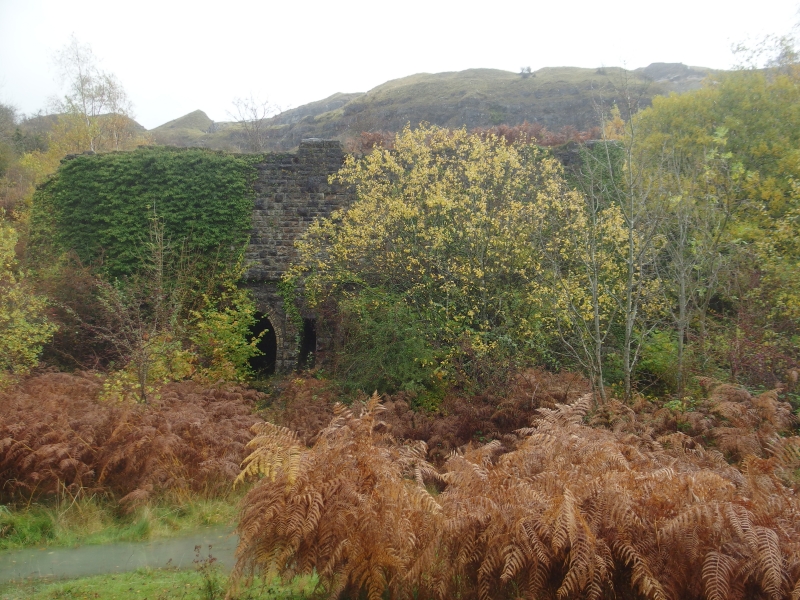
Late C19 limekilns, probably built for making mortar when the Merthyr, Tredegar and Abergavenny Railway (1862, closed 1958) was doubled in 1877: this involved widening the adjacent 8-arch Nant Dyar Viaduct . The limeworks was probably built when the railway was begun in 1862, for mortar and stone; another set of kilns located to the S (in deteriorating condition) is probably contemporary. Both kilns were served by a railway siding. By 1896, 30 men were employed at the quarry; 22 in 1944. The kilns ceased operation in the 1930s, but were refired during the war for agricultural lime, special hoods being made to place over the kilns during blackouts. The kilns finally ceased in 1955. After the railway closed in 1958, stone was brought by lorry, the quarry closing shortly after.
Large rectangular kiln with battered walls. Rock-faced limestone construction. Some rock-faced copings remain. Paired round-headed drawing arches to left and right, set within shallow straight-headed recesses. Yellow brick arch-rings of three header courses. Small corner stoking-holes. Narrow central doorway with stone lintel leads to full-height straight flight of narrow stone steps to loading stage. Crucibles are infilled, but stair is still accessible.
Listed as a large well preserved late C19 block of limekilns, a prominent survival of the important industrial landscape of the Clydach Gorge.
External links are from the relevant listing authority and, where applicable, Wikidata. Wikidata IDs may be related buildings as well as this specific building. If you want to add or update a link, you will need to do so by editing the Wikidata entry.


Other nearby listed buildings
