Approximate Location Map
Large Map »
Latitude: 53.0083 / 53°0'29"N
Longitude: -3.4433 / 3°26'35"W
OS Eastings: 303253
OS Northings: 346638
OS Grid: SJ032466
Mapcode National: GBR 6L.GJ2W
Mapcode Global: WH77T.2NL4
Plus Code: 9C5R2H54+8M
Entry Name: Old house and outbuildings at north side of Wyn Llan
Listing Date: 7 August 2000
Last Amended: 7 August 2000
Grade: II
Source: Cadw
Source ID: 23877
Building Class: Agriculture and Subsistence
ID on this website: 300023877
Location: At the north of the village of Bettws Gwerfil Goch, standing to the east side of the road to Melin y wig.
County: Denbighshire
Town: Corwen
Community: Betws Gwerfil Goch (Betws Gwerful Goch)
Community: Betws Gwerfil Goch
Locality: Bettws Gwerfil Goch
Traditional County: Merionethshire
Tagged with: Architectural structure
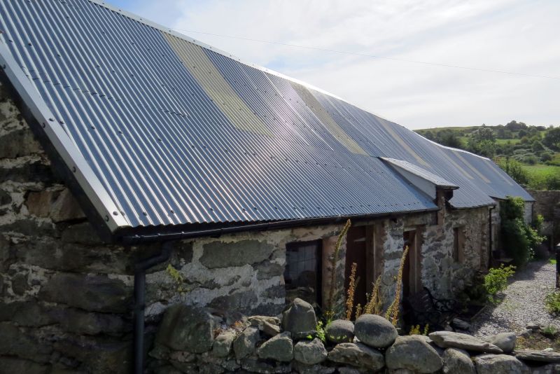
The range slopes down from the road eastwards. The upper three bays of this range, adjacent to the road, are the original structure, possibly of the C16/17, consisting of a heated two-bay domestic part and a single bay byre, but an original internal communication between house and byre cannot be demonstrated. This building, of a derivative type related to the classic longhouse, has been altered to increase the distinction of house and byre by the insertion of a stone cross wall on the line of truss 2. This wall is evidently secondary as it clashes with an external doorway. The latter doorway has been altered to a window. The building was extended eastwards at an early date by the addition of a two-bay barn and a still later two-bay byre or stable with loft.
A house with agricultural outbuildings in tandem, in local rubble stonework. Roof now of steel sheeting carried on the original trusses, purlins and crosswalls. All ground storey access and most of the windows are in the long south-facing 'front' elevation. The first part of the structure consisting of three bays is about 14 metres in length. Square window, two wide doorways, and a raised window through the eaves in the first two domestic bays; two door openings, one converted to a window, in the third bay which is interpreted as a byre.
The barn is slightly narrower, about 8 metres in length, and stands on a slightly altered alignment. The change in masonry at the junction is apparent at both sides. Large doorway in the first bay (bay four) and a small rear window opposite. Its second bay (bay five) has a loft opening and a blocked small opening below.
A still later lofted byre or stable of two bays extends a further 5 metres east and has outside stone stairs leading to the loft door in the gable end. The change in masonry indicative of a different date is again apparent at both sides. This part has a door and window with cyclopean lintels and a small loft window above; at rear a small square window under a timber lintel and a small loft window above.
The original three-bay building has stone gable walls. Truss 1 consists of tie, collar and truncated king post. Truss 2 consists of tie and two raking struts, and there is an inserted cross wall of stone beneath. There is a large hearth in the gable wall against the road, with a remnant of a bread oven at its left. Additional cross beams suggest the addition of informal lofting.
An exceptional survival of a long-house-derived range, of house and cowhouse in line, subsequently extended to form a long linerar agricultural range: an important early survival of a building type becoming increasingly scarce in this region.
External links are from the relevant listing authority and, where applicable, Wikidata. Wikidata IDs may be related buildings as well as this specific building. If you want to add or update a link, you will need to do so by editing the Wikidata entry.


Other nearby listed buildings
