Approximate Location Map
Large Map »
Latitude: 53.3029 / 53°18'10"N
Longitude: -3.4175 / 3°25'3"W
OS Eastings: 305632
OS Northings: 379380
OS Grid: SJ056793
Mapcode National: GBR 4ZK7.XP
Mapcode Global: WH76G.G7TQ
Plus Code: 9C5R8H3J+5X
Entry Name: Tomb group in St Bridget's Churchyard
Listing Date: 10 December 2001
Last Amended: 10 December 2001
Grade: II*
Source: Cadw
Source ID: 25955
Building Class: Religious, Ritual and Funerary
ID on this website: 300025955
Location: About 10 m south-east of the chancel of Dyserth Church.
County: Denbighshire
Community: Dyserth
Community: Dyserth
Locality: Dyserth Village
Built-Up Area: Dyserth
Traditional County: Flintshire
Tagged with: Tomb
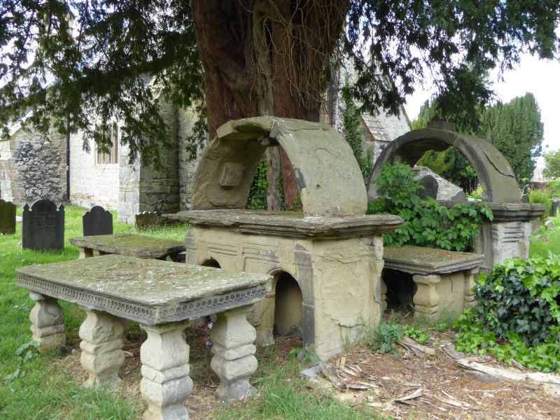
A late-C17 tomb group mainly of the Hughes family. Much of the date information is eroded and illegible. An inscription in the church (1906) states that "beneath the canopied tombstones in the adjoining churchyard are interred the remains of many generations of the ancient family of Hughes of Llewerllyd in this parish, descended in the male line from Prince Cadwalladr."
The single stone at west of the main set is to Catherine --- of Llewerllyd, in C17 lettering. The hooded (i.e. canopied) and arched tomb to north of the middle set is dated 1676 and has cherubs and skulls and crossbones. The next is to John Hughes of Castell 1668 and others. The next, also hooded and arched, carries a skull and crossbones and painted heraldry. The fourth has a skull and crossbones and a guilloche border. The single tomb to the east of the main set has heraldry and a skull and crossbones.
A group of tombstones, aligned in three ranks, possibly part only of an originally more extensive group. There are four tombs in a north-south alignment (two of which are made conspicuous with arched hoods), constituting the main rank or group, plus one tomb to the west and one to the east, making six in the now identifiable whole group. All are in sandstone, with ledger stones raised on arches or balusters. Other balusters of similar form, preserved in the church, may come from lost tombs in this group; illegibility makes it impossible to say if others still extant belong logically to this group.
A fine set of C17 tombstones of a locally characteristic type including two exceptional hooded tombs, commemorating a local gentry family; with contemporary carving, lettering and painting, standing in a compact group.
External links are from the relevant listing authority and, where applicable, Wikidata. Wikidata IDs may be related buildings as well as this specific building. If you want to add or update a link, you will need to do so by editing the Wikidata entry.


Other nearby listed buildings
