History in Structure

Lychgate at Church of St Curig

A Grade II Listed Building in Llangurig, Powys

More Photos »
Approximate Location Map
Large Map »

Coordinates

Latitude: 52.4064 / 52°24'23"N

Longitude: -3.6064 / 3°36'22"W

OS Eastings: 290819

OS Northings: 279927

OS Grid: SN908799

Mapcode National: GBR 9D.PGQL

Mapcode Global: VH5C2.FST3

Plus Code: 9C4RC94V+HC

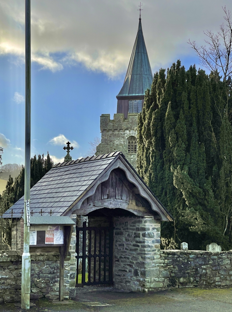
Entry Name: Lychgate at Church of St Curig

Listing Date: 24 March 2005

Last Amended: 24 March 2005

Grade: II

Source: Cadw

Source ID: 84296

ID on this website: 300084296

Location: On the S side of the A44 and forming the main entrance to the church.

County: Powys

Community: Llangurig

Community: Llangurig

Traditional County: Montgomeryshire

Tagged with: Lychgate

Find accommodation in
Llangurig

History

Lychgate dated 1740, some of the external detail C19.

Exterior

Gabled lychgate constructed of random stone under a slate roof. Entrances to N and S, the shallow arched wooden tie beams with depressed ogee heads. C19 vertical boarding to gables, with decorative barge boards with wave moulding to N side and zig-zag moulding to S side.

Two-bay roof, the central truss also with a depressed ogee-arched tie-beam, supported on corbels. Raked struts above tie-beam; diagonal wind-braces above purlins, all the timbers pegged. On the N side of the central tie-beam is a carved inscription reading 'GD (W) SH 1740 DG (C) IO'. The former initials refer to the churchwardens, George David and Solomon Hamer, the latter initials possibly to the carpenters. A pair of double wooden gates are fixed beneath, with mid-rail and open panels with trefoiled heads.

Reasons for Listing

Listed as an unusually well-detailed C18 lychgate, and for group value with the Church of St Curig and other structures in the village.

External Links

External links are from the relevant listing authority and, where applicable, Wikidata. Wikidata IDs may be related buildings as well as this specific building. If you want to add or update a link, you will need to do so by editing the Wikidata entry.

Recommended Books

Other nearby listed buildings

  • II Memorial to Chevalier Lloyd
    In the centre of the village. Located on the pavement, immediately E of the lychgate.
  • II The Blue Bell Inn
    Fronting the N side of the main road, opposite the church. It is at the junction with a by-road which runs N towards Llanidloes.
  • II Memorial Fountain
    On the N side of the main road in the centre of Llangurig, to the E of the church. Flanked by low rubble walls retaining the village green.
  • II* Church of St Curig
    On the SW side of the village, reached from the main road and set down towards the N bank of the River Wye.
  • II Milestone
    In the centre of the village, on the N side of the main road, immediately R of the water-fountain.
  • II Penybont & Glanyrafon, including forecourt wall
    In Llangurig, to the E of the church, at the side of the by-road that runs S along the Wye Valley; immediately below the junction with the main A44. Penybont fronts the road and Glanyrafon is at right
  • II No.1
    On the W side of a by-road which runs N towards Llanidloes, and close to the junction with the main A44.
  • II No.2
    On the W side of a by-road which runs N towards Llanidloes, and close to the junction with the main A44.

BritishListedBuildings.co.uk is an independent online resource and is not associated with any government department. All government data published here is used under licence. Please do not contact BritishListedBuildings.co.uk for any queries related to any individual listed building, planning permission related to listed buildings or the listing process itself.

British Listed Buildings is a Good Stuff website.