Approximate Location Map
Large Map »
Latitude: 52.5711 / 52°34'15"N
Longitude: -0.2388 / 0°14'19"W
OS Eastings: 519460
OS Northings: 298485
OS Grid: TL194984
Mapcode National: GBR HZQ.SJW
Mapcode Global: WHHNK.9MKT
Plus Code: 9C4XHQC6+CF
Entry Name: Gatepiers to Gravel Walk
Listing Date: 7 May 1973
Grade: II
Source: Historic England
Source ID: 1126970
English Heritage Legacy ID: 49649
ID on this website: 101126970
Location: Peterborough, Cambridgeshire, PE1
County: City of Peterborough
Electoral Ward/Division: Central
Parish: Non Civil Parish
Built-Up Area: Peterborough
Traditional County: Northamptonshire
Lieutenancy Area (Ceremonial County): Cambridgeshire
Tagged with: Gatepost
PETERBOROUGH
1.
1500
PRECINCTS
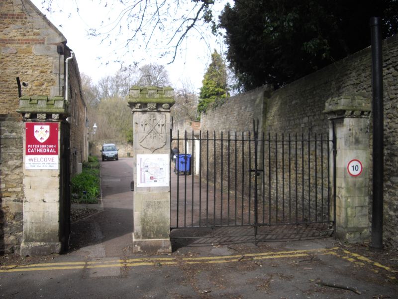
Gatepiers to Gravel Walk
TL 1998 SW 3/358
II
2.
1820. 3 stone gatepiers with crenellated cornice and shields with arms
and heraldic motifs of the See. Iron gates.
Listing NGR: TL1946098485
External links are from the relevant listing authority and, where applicable, Wikidata. Wikidata IDs may be related buildings as well as this specific building. If you want to add or update a link, you will need to do so by editing the Wikidata entry.


Other nearby listed buildings
