Approximate Location Map
Large Map »
Latitude: 53.2645 / 53°15'52"N
Longitude: -3.4634 / 3°27'48"W
OS Eastings: 302490
OS Northings: 375170
OS Grid: SJ024751
Mapcode National: GBR 4Z7P.ZG
Mapcode Global: WH65H.R6YN
Plus Code: 9C5R7G7P+RJ
Entry Name: Gwernigron Farmhouse
Listing Date: 16 November 1962
Last Amended: 6 December 2002
Grade: II
Source: Cadw
Source ID: 1381
Building Class: Domestic
ID on this website: 300001381
Location: 500m W of the A525 St Asaph Road, 400m N of the A55.
County: Denbighshire
Community: Bodelwyddan
Community: Bodelwyddan
Locality: Gwernigron
Traditional County: Flintshire
Tagged with: Farmhouse
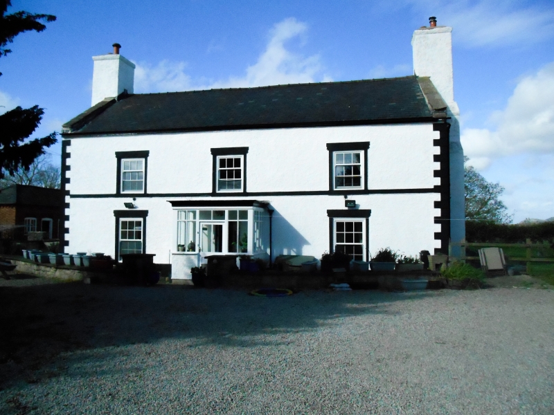
A large C17 farmhouse. Windows of the C18 or C19, the sashes below appear late. C19 or early C20 porch with flat roof. Coherent re-dressing of the front with white-painted render, and with quoins, string course and window surrounds picked out in black.
A farmhouse of 2-storeys and 3-windows, in rough white-painted render on stonework, with rusticated quoins, string course and window surrounds picked out in black paint. The roof is of slate with coped gables at each end and massive end chimney stacks, also rendered and white painted. The string course is at the level of the upper sills.
Nine-pane hornless unequal-sash windows above, 12-pane horned sash windows below and modern porch.
Later rear wing in flemish-bond brickwork: 2 windows at raised level. Hipped slate roof, brick chimney.
Not inspected but said to retain chamfered, wide fireplaces with timber bressummers, somewhat altered. Lozenge paving in hall. Six-panel doors at ground and first floors. Attic with ledged doors, oak floor and purlins. Some purlins at west, modern. Brick barrel-vaulted cellar, east.
A well-preserved substantial farmhouse of the late C17 with modifications giving it a coherent character in the C19.
External links are from the relevant listing authority and, where applicable, Wikidata. Wikidata IDs may be related buildings as well as this specific building. If you want to add or update a link, you will need to do so by editing the Wikidata entry.


Other nearby listed buildings
