Approximate Location Map
Large Map »
Latitude: 52.2412 / 52°14'28"N
Longitude: -3.1537 / 3°9'13"W
OS Eastings: 321319
OS Northings: 260956
OS Grid: SO213609
Mapcode National: GBR F0.0SFV
Mapcode Global: VH69K.9X3T
Plus Code: 9C4R6RRW+FG
Entry Name: Farm Range adjoining E. end of Brookside Farmhouse
Listing Date: 29 April 1993
Last Amended: 29 April 1993
Grade: II
Source: Cadw
Source ID: 9231
Building Class: Agriculture and Subsistence
ID on this website: 300009231
County: Powys
Community: New Radnor (Maesyfed)
Community: New Radnor
Traditional County: Radnorshire
Tagged with: Farm
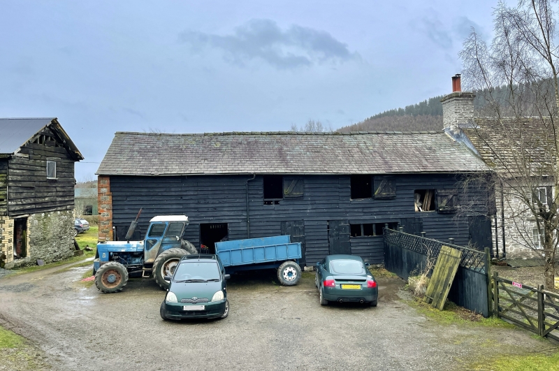
Probably late C18 with later refacing.
Two-storey cowhouses, rubble gable wall with brick dressings. Weather-boarded front, slate roof. Six boarded doors, loft shutters. Interior subdivided with boarded partition walls, transverse stalling and loose boxes. Floorboards to loft. Tie beam trusses with two pairs of raking braces, roof pitch raised, studwork walls with jowled posts.
Group value with the farmhouse.
External links are from the relevant listing authority and, where applicable, Wikidata. Wikidata IDs may be related buildings as well as this specific building. If you want to add or update a link, you will need to do so by editing the Wikidata entry.


Other nearby listed buildings
