Approximate Location Map
Large Map »
Latitude: 53.1462 / 53°8'46"N
Longitude: -3.4899 / 3°29'23"W
OS Eastings: 300447
OS Northings: 362043
OS Grid: SJ004620
Mapcode National: GBR 6J.5YJY
Mapcode Global: WH662.C5CW
Plus Code: 9C5R4GW6+F2
Entry Name: Glasmor
Listing Date: 15 December 1998
Last Amended: 15 December 1998
Grade: II
Source: Cadw
Source ID: 20986
Building Class: Domestic
ID on this website: 300020986
Location: Located prominently on the corner, at the crossroads at the S end of the village street.
County: Denbighshire
Town: Denbigh
Community: Nantglyn
Community: Nantglyn
Traditional County: Denbighshire
Tagged with: Farmhouse
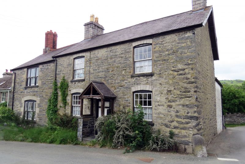
Mid C19 village farmhouse with C18 origins. Glasmor stands at the village cross-roads, with two of its contemporary agricultural ranges adjacent and opposite and a third approximately 420m to the E. As such this forms an unusual village farmstead siting, rarely seen in this area. One of the farm buildings is dated 1762 which provides a context for the primary farmhouse. In the C19 it served for a while as an inn, named 'The Black;' it has remained in use as a farmhouse this century.
Large 2-storey, L-plan farmhouse of coursed local rubble construction, with limestone ashlar detailing; slate roof with oversailing verges. The house consists of a primary 2-window main block, with an additional one-window section stepped-down and adjoining to the L. The former has simple end chimneys with plain cornices, the latter a late C19, star-shaped end chimney to the L; of brick with simple cornice band. Near-symmetrical primary section with central entrance via a part-open, gabled wooden porch, on a slate-stone plinth; 6-panel door with simple rectangular overlight. 16-pane unhorned sash windows to both floors, with projecting slate sills and cambered heads; limestone voussoirs. The additional block, to the L, has a tripartite window with prominent quoins to each floor, that to the ground floor with cambered head as before; plain Victorian sashes with 4-pane central sections and narrow flanking 2-pane sections.
The rear elevations are of whitened rubble. The primary section has a lower, gabled rear wing with end chimney; 4-pane sash to the first floor and modern windows to its R return, that to the first floor contained within a simple gabled dormer. Extruded in the angle between the main block and its rear projection is a 2-part rubble lean-to with slated roof, the larger, left-hand section of which has a part-glazed entrance; 2 modern windows to the L. The rear of the additional block has 12-pane unhorned sashes to both floors, the cambered stone heads and quoins of which are painted black.
Plain C19 interiors with simple architraves to panelled doors and a simple stick baluster stair.
Listed for its special interest as a C19 farmhouse with earlier origins, retaining good external character and unusually sited within the village.
Group value with the Agricultural Range to the S of Glasmor.
External links are from the relevant listing authority and, where applicable, Wikidata. Wikidata IDs may be related buildings as well as this specific building. If you want to add or update a link, you will need to do so by editing the Wikidata entry.


Other nearby listed buildings
