Approximate Location Map
Large Map »
Latitude: 51.3207 / 51°19'14"N
Longitude: -2.2084 / 2°12'30"W
OS Eastings: 385570
OS Northings: 157979
OS Grid: ST855579
Mapcode National: GBR 1ST.0H0
Mapcode Global: VH972.N2VC
Plus Code: 9C3V8QCR+7J
Entry Name: The Dust Hole the King's Arms Public House
Listing Date: 26 November 1976
Grade: II
Source: Historic England
Source ID: 1021528
English Heritage Legacy ID: 313888
ID on this website: 101021528
Location: Trowbridge, Wiltshire, BA14
County: Wiltshire
Civil Parish: Trowbridge
Built-Up Area: Trowbridge
Traditional County: Wiltshire
Lieutenancy Area (Ceremonial County): Wiltshire
Church of England Parish: Trowbridge St James
Church of England Diocese: Salisbury
Tagged with: Pub
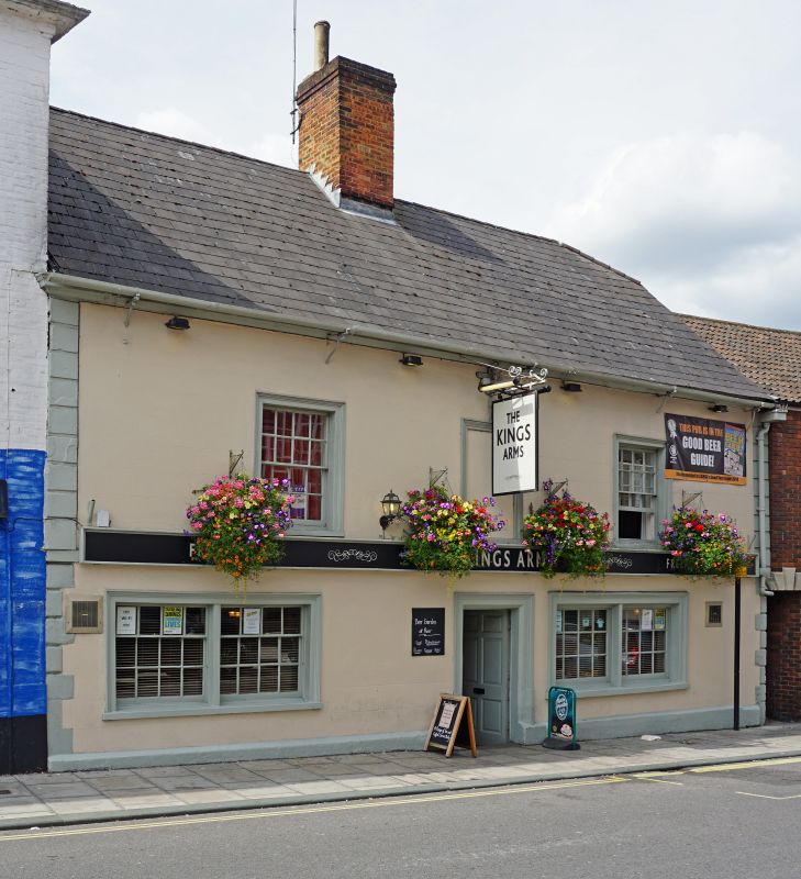
CASTLE STREET
1.
5411
(West Side)
Nos 5 and 5A
(The King's Arms
Public House)
[The Dust Hole]
ST 8557 7/160
II GV
2.
C17 or early C18, known as the 'Dusthole'. 2 storeys, stuccoed and grooved to
simulate ashlar. Stone plinth, quoins (rustic to ground floor, draughted piers
above) and moulded eaves cornice to Welsh slate roof, 1/4 hipped to right; central
brick stack. Three 1st floor windows with architraves, centre blocked, others
glazing bar sashes. Central doorway with architrave and 6 panel door flanked by
modern 2 light single hung sashes also with architraves. The rear is rubble built
and has 2 glazing bar sash windows with dressed stone surrounds and a central blocked
2 light ovolo mullioned window.
Gabled 2 storey brick wing to rear with double roman tiles and 2 brick chimneys,
1 with gable and partly stepped. 2 windows with reeded inner edges to south.
To north a 3 light raking top dormer and 2 first floor 4 light weavers windows.
Interior much altered but attic still interesting a) because of 2 bastard cruck
trusses [to main collars] and b) because of diamond scratched mid C19 grafitti
on panes in window of extension.
Nos I to 6 (consec) including 5A form a group.
Listing NGR: ST8557057979
External links are from the relevant listing authority and, where applicable, Wikidata. Wikidata IDs may be related buildings as well as this specific building. If you want to add or update a link, you will need to do so by editing the Wikidata entry.


Other nearby listed buildings
