Approximate Location Map
Large Map »
Latitude: 51.6178 / 51°37'3"N
Longitude: -2.0911 / 2°5'27"W
OS Eastings: 393791
OS Northings: 190997
OS Grid: ST937909
Mapcode National: GBR 2QM.D55
Mapcode Global: VH95L.PLXP
Plus Code: 9C3VJW95+4H
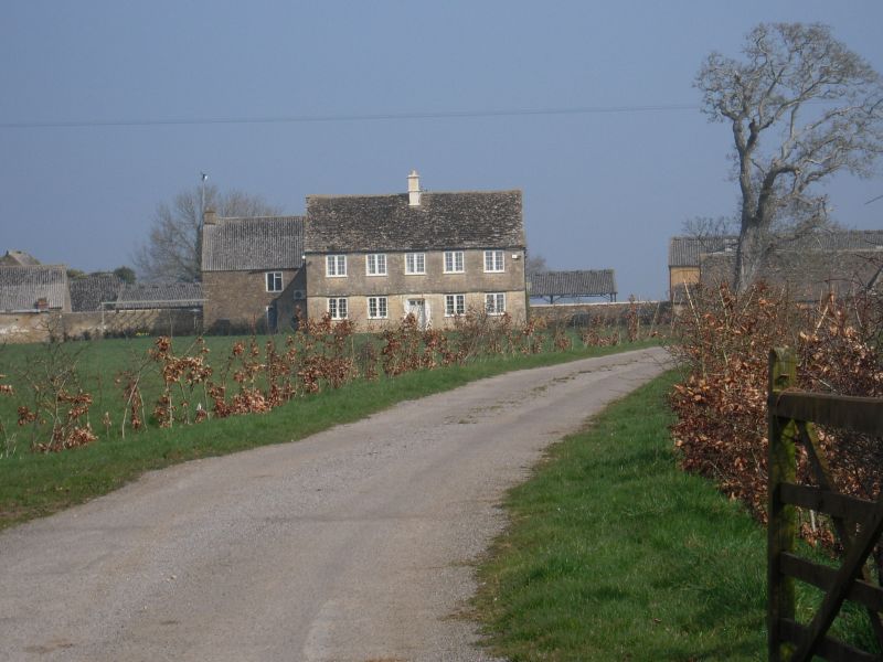
Entry Name: Bishoper Farmhouse
Listing Date: 16 July 1987
Grade: II
Source: Historic England
Source ID: 1022248
English Heritage Legacy ID: 315718
ID on this website: 101022248
Location: Wiltshire, SN16
County: Wiltshire
Civil Parish: Hankerton
Traditional County: Wiltshire
Lieutenancy Area (Ceremonial County): Wiltshire
Church of England Parish: Hankerton
Church of England Diocese: Bristol
Tagged with: Farmhouse
ST 99 SW HANKERTON CRUDWELL
2/96 Bishoper Farmhouse
II
Farmhouse. Late C17 with C19 refenestration. Coursed rubble
with flush rusticated dressed stone quoins, timber lintels and
gabled stone slate roof with central brick stack. L-shaped plan:
2-storey, 5-window south front. Windows are 2-light small leaded
pane C19 casements in original C17 openings. Central gabled stone
porch with 6-panel door having two top lights. Continuous string
course with flush relieving arches over ground floor windows. One
original 3-light ovolo-moulded mullion to east wall of rear wing.
Listing NGR: ST9379190997
External links are from the relevant listing authority and, where applicable, Wikidata. Wikidata IDs may be related buildings as well as this specific building. If you want to add or update a link, you will need to do so by editing the Wikidata entry.


Other nearby listed buildings
