Latitude: 51.5116 / 51°30'41"N
Longitude: -2.0561 / 2°3'21"W
OS Eastings: 396203
OS Northings: 179191
OS Grid: ST962791
Mapcode National: GBR 2S0.30Z
Mapcode Global: VHB3N.98WJ
Plus Code: 9C3VGW6V+MH
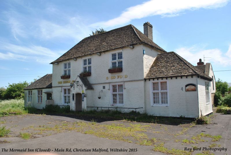
Entry Name: The Mermaid Inn
Listing Date: 25 November 1987
Grade: II
Source: Historic England
Source ID: 1022470
English Heritage Legacy ID: 316271
ID on this website: 101022470
Location: Christian Malford, Wiltshire, SN15
County: Wiltshire
Civil Parish: Christian Malford
Built-Up Area: Christian Malford
Traditional County: Wiltshire
Lieutenancy Area (Ceremonial County): Wiltshire
Church of England Parish: Christian Malford
Church of England Diocese: Bristol
Tagged with: Inn
CHRISTIAN MALFORD MAIN ROAD ST 97 NE (south side) 5/147 The Mermaid Inn II Inn, formerly farmhouse, early C18, painted rubble stone with painted ashlar dressings and hipped stone slate roof with rear stacks. Two storeys and attic. Flush quoins and moulded eaves cornice. Three window front range of 2-light hollow-moulded recessed mullion-and transom windows with small-paned lights. Centre depressed-arched door in C19 ashlar gabled porch with depressed-arched entry and side buttresses. Dripcourse with pendant hoodmoulds to ground floor. C20 matching single storey additions each end. Large south-east rear wing with coped south gable. Low hipped south-west rear wing has west side 2-light each floor, upper window with cast-iron small-paned glazing. Old photographs show a large 2-storey stable range to south-west, now demolished.
Listing NGR: ST9620379191
External links are from the relevant listing authority and, where applicable, Wikidata. Wikidata IDs may be related buildings as well as this specific building. If you want to add or update a link, you will need to do so by editing the Wikidata entry.


Other nearby listed buildings