Approximate Location Map
Large Map »
Latitude: 51.5417 / 51°32'29"N
Longitude: -1.9052 / 1°54'18"W
OS Eastings: 406668
OS Northings: 182533
OS Grid: SU066825
Mapcode National: GBR 3T4.C3V
Mapcode Global: VHB3J.XJN0
Plus Code: 9C3WG3RV+MW
Entry Name: 27, High Street
Listing Date: 15 August 1985
Grade: II
Source: Historic England
Source ID: 1022696
English Heritage Legacy ID: 316809
ID on this website: 101022696
Location: Royal Wootton Bassett, Wiltshire, SN4
County: Wiltshire
Civil Parish: Royal Wootton Bassett
Built-Up Area: Wootton Bassett
Traditional County: Wiltshire
Lieutenancy Area (Ceremonial County): Wiltshire
Church of England Parish: Wootton Bassett St Bartholomew and All Saints
Church of England Diocese: Salisbury
Tagged with: Building
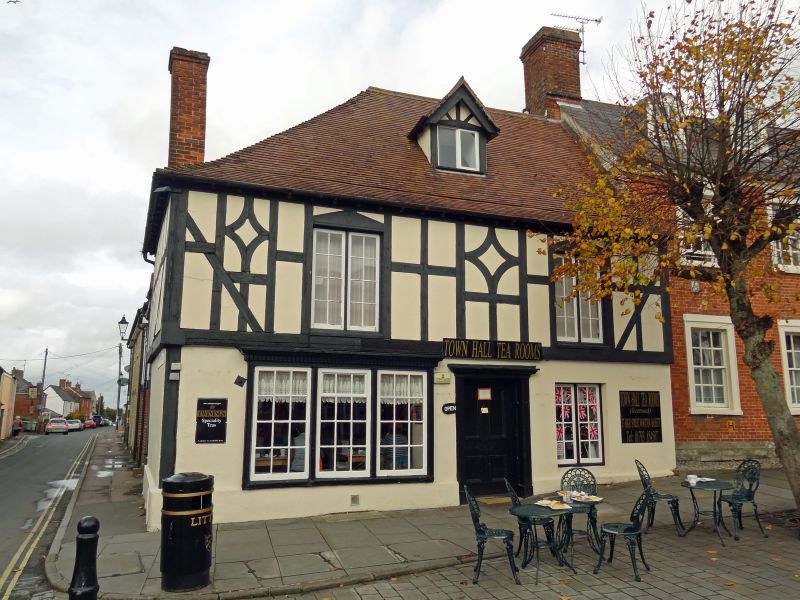
SU 08 SE WOOTTON BASSETT HIGH STREET
(north west side)
11/127 No. 27
GV II
House, now shop with office over. C16 fragments and late C18
stone, with applied timber framing. C20 tiled roof with 1 dormer
of 1937. 2-storey and cellar, 2 bays, entrance in left, wider bay.
Stacks at centre and gable. C20 shopfront. Timber casement
windows to first floor. Building originally had rear open hall at
right angles to High Street with fire blackened timbers. Remains
of 2 cruck trusses with saddle apex and one surviving windbrace.
Fire beams at ground floor level, in C18 front block. (1979 report
by RCHM in NMR).
Listing NGR: SU0666782530
External links are from the relevant listing authority and, where applicable, Wikidata. Wikidata IDs may be related buildings as well as this specific building. If you want to add or update a link, you will need to do so by editing the Wikidata entry.


Other nearby listed buildings
