Approximate Location Map
Large Map »
Latitude: 51.6466 / 51°38'47"N
Longitude: -1.9303 / 1°55'48"W
OS Eastings: 404921
OS Northings: 194203
OS Grid: SU049942
Mapcode National: GBR 3RR.QSW
Mapcode Global: VHB2Y.HWD2
Plus Code: 9C3WJ3W9+JV
Entry Name: 15, Fore Street
Listing Date: 17 April 1986
Grade: II
Source: Historic England
Source ID: 1023063
English Heritage Legacy ID: 317689
ID on this website: 101023063
Location: Ashton Keynes, Wiltshire, SN6
County: Wiltshire
Civil Parish: Ashton Keynes
Built-Up Area: Ashton Keynes
Traditional County: Wiltshire
Lieutenancy Area (Ceremonial County): Wiltshire
Church of England Parish: Ashton Keynes
Church of England Diocese: Bristol
Tagged with: Building
SU 09 SW ASHTON KEYNES FORE STREET
(north side)
10/40 No 15
II
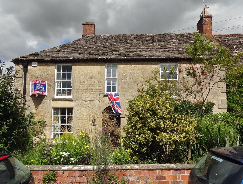
House. c.1850. Squared limestone rubble with quoins and
dressings. Stone slate roof. Two storey, 3 bays. Recessed round
headed central entrance with C20 glazed door and original radial
fanlight. Keyed architrave. Twelve-pane sashes with recessed
boxes, 8-pane to first floor centre bay. Roof hipped left, and
rear stack. Front garden wall in rat-trap bond with stone copings
swept up at junctions and openings, continuous with April Cottage
(q.v.).
Listing NGR: SU0492194203
External links are from the relevant listing authority and, where applicable, Wikidata. Wikidata IDs may be related buildings as well as this specific building. If you want to add or update a link, you will need to do so by editing the Wikidata entry.


Other nearby listed buildings
