Approximate Location Map
Large Map »
Latitude: 51.0677 / 51°4'3"N
Longitude: -1.7977 / 1°47'51"W
OS Eastings: 414271
OS Northings: 129843
OS Grid: SU142298
Mapcode National: GBR 517.VR4
Mapcode Global: FRA 7639.KG8
Plus Code: 9C3W3692+3W
Entry Name: High Street
Listing Date: 12 October 1972
Grade: II
Source: Historic England
Source ID: 1023683
English Heritage Legacy ID: 319174
ID on this website: 101023683
Location: Salisbury, Wiltshire, SP1
County: Wiltshire
Civil Parish: Salisbury
Built-Up Area: Salisbury
Traditional County: Wiltshire
Lieutenancy Area (Ceremonial County): Wiltshire
Church of England Parish: Salisbury St Thomas and St Edmund
Church of England Diocese: Salisbury
Tagged with: Building
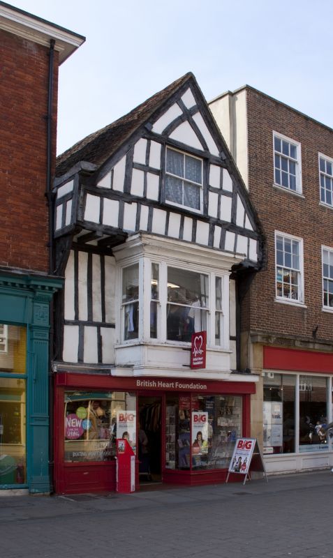
HIGH STREET
1.
1594
(West Side)
No 40
SU 1429 NW 3/77
II GV
2.
Formerly shown with Nos 36 and 38 since demolished.
C16 with C19 alterations. 2 storeys and attic timber frame exposed lath plaster
infilling. Gable to front, attic floor is jettied. Attic casement. 1st
floor has C18/Cl9 rectangular bay window with coved cornice and panelled apron.
Plain double C19 shop front on ground floor.
Nos 40 to 44 (even) form a group.
Listing NGR: SU1427129843
External links are from the relevant listing authority and, where applicable, Wikidata. Wikidata IDs may be related buildings as well as this specific building. If you want to add or update a link, you will need to do so by editing the Wikidata entry.


Other nearby listed buildings
