Approximate Location Map
Large Map »
Latitude: 51.1536 / 51°9'13"N
Longitude: -1.7081 / 1°42'29"W
OS Eastings: 420509
OS Northings: 139416
OS Grid: SU205394
Mapcode National: GBR 50D.LYR
Mapcode Global: VHC31.B8VG
Plus Code: 9C3W573R+FP
Entry Name: Wyndham Farmhouse
Listing Date: 29 May 1987
Grade: II
Source: Historic England
Source ID: 1023938
English Heritage Legacy ID: 319917
ID on this website: 101023938
Location: Allington, Wiltshire, SP4
County: Wiltshire
Civil Parish: Allington
Traditional County: Wiltshire
Lieutenancy Area (Ceremonial County): Wiltshire
Church of England Parish: Allington with Boscombe St John the Baptist
Church of England Diocese: Salisbury
Tagged with: Farmhouse
ALLINGTON WYNDHAM LANE
SU 23 NW
(south-west side)
4/19 Wyndham Farmhouse
II
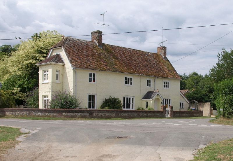
Farmhouse, now house. Later C18 incorporating a mid C17 three bay
stone and timber-framed cottage. Colourwashed flint with brick
quoins and banding. Tiled roof. Two storeys and attic, 3 bays,
symmetrical plan, with fourth bay added on left in early C19, with
rear stack. Central gabled porch, also C19, with slate roof and
arched opening, containing original 6-panelled door set forward.
Tripartite 4-paned sashes to ground floor, 2 and 3-light casements
above, all with wide frames, and 4-pane sash to extension. Gabled
dormer to rear. Gable stacks. Early C20 two-storey bay added to
gable of extension, of red brick and roughcast. Late C18 and C19.
Lean-to extensions to right gable and rear, the centre rear lean-to
with pantiles.
Interior: north room has chamfered spine beam with ogee and bar
stops. Roof of 5 bays with 2 tiers of purlins and chamfered
windbraces to centre bay.
(R.C.H.M. Survey)
Listing NGR: SU2050939416
External links are from the relevant listing authority and, where applicable, Wikidata. Wikidata IDs may be related buildings as well as this specific building. If you want to add or update a link, you will need to do so by editing the Wikidata entry.


Other nearby listed buildings
