Approximate Location Map
Large Map »
Latitude: 54.9736 / 54°58'24"N
Longitude: -1.6178 / 1°37'4"W
OS Eastings: 424561
OS Northings: 564396
OS Grid: NZ245643
Mapcode National: GBR SNN.7P
Mapcode Global: WHC3R.38W0
Plus Code: 9C6WX9FJ+CV
Entry Name: Gunn Tomb About 10 Metres East of South Transept of Church of St Andrew
Listing Date: 30 March 1987
Grade: II
Source: Historic England
Source ID: 1024817
English Heritage Legacy ID: 304742
ID on this website: 101024817
Location: St Andrew's Church, Newcastle Helix, Newcastle upon Tyne, Tyne and Wear, NE1
County: Newcastle upon Tyne
Electoral Ward/Division: Westgate
Parish: Non Civil Parish
Built-Up Area: Newcastle upon Tyne
Traditional County: Northumberland
Lieutenancy Area (Ceremonial County): Tyne and Wear
Church of England Parish: Newcastle St Andrew
Church of England Diocese: Newcastle
Tagged with: Building
NZ 2464 SE NEWCASTLE UPON TYNE NEWGATE STREET
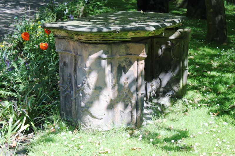
20/417 (west side)
Gunn tomb about lom
east of south transept
of Church of St.Andrew
G.V. II
Table tomb. Late C18. Commemorates members of the Gunn and Raisbeck families
from 1779 to 1846. Sandstone ashlar. Gothic style. Moulded-edged slab on solid
serpentine ends; central recessed supporting slab. End panels have Gothic shafts
and blind tracery.
Listing NGR: NZ2456164395
External links are from the relevant listing authority and, where applicable, Wikidata. Wikidata IDs may be related buildings as well as this specific building. If you want to add or update a link, you will need to do so by editing the Wikidata entry.


Other nearby listed buildings
