Latitude: 54.9716 / 54°58'17"N
Longitude: -1.6025 / 1°36'8"W
OS Eastings: 425545
OS Northings: 564178
OS Grid: NZ255641
Mapcode National: GBR SQW.2P
Mapcode Global: WHC3R.C95K
Plus Code: 9C6WX9CX+J2
Entry Name: The Keelmen's Hospital
Listing Date: 14 June 1954
Grade: II*
Source: Historic England
Source ID: 1024902
English Heritage Legacy ID: 304465
ID on this website: 101024902
Location: Battle Field, Newcastle upon Tyne, Tyne and Wear, NE1
County: Newcastle upon Tyne
Electoral Ward/Division: Ouseburn
Parish: Non Civil Parish
Built-Up Area: Newcastle upon Tyne
Traditional County: Northumberland
Lieutenancy Area (Ceremonial County): Tyne and Wear
Church of England Parish: Newcastle Christ Church
Church of England Diocese: Newcastle
Tagged with: Hospital building
NZ 26 SE NEWCASTLE UPON TYNE CITY ROAD
(north side)
12/160 The Keelmen's Hospital
14/6/54
G.V. II*
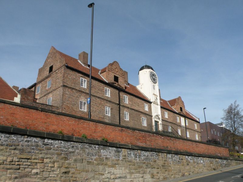
Almshouses, now students' residences. 1701 for poor keelmen and keelmen's
widows; paid for by the keelmen. English garden wall bond brick; roof of renewed
pantiles with lead dome on tower. Square plan round a courtyard. 2 storeys,
9 irregular bays with central tower. Central half-glazed door, with side-and
overlights, in plain surround under pediment; flanking pilasters. Pilasters
also to 2 upper stages of tower over entrance, with commemorative panel and
sundial; rounded top storey has single clock face under dome with boat wind
vane. Casement windows have segmental brick arches. Commemorative panel at
top right. Dormer, central at each side of roof, has shaped gable with header
coping continuing as scrolled pattern, and central lozenge of headers. First
floor string. 4 brick chimneys. Source: H. Bourne, History of Newcastle upon
Tyne, Newcastle 1736, p.153.
Listing NGR: NZ2554564178
External links are from the relevant listing authority and, where applicable, Wikidata. Wikidata IDs may be related buildings as well as this specific building. If you want to add or update a link, you will need to do so by editing the Wikidata entry.


Other nearby listed buildings