Approximate Location Map
Large Map »
Latitude: 54.9619 / 54°57'42"N
Longitude: -1.3936 / 1°23'36"W
OS Eastings: 438926
OS Northings: 563192
OS Grid: NZ389631
Mapcode National: GBR LCQ2.23
Mapcode Global: WHD4Z.KKL1
Plus Code: 9C6WXJ64+PH
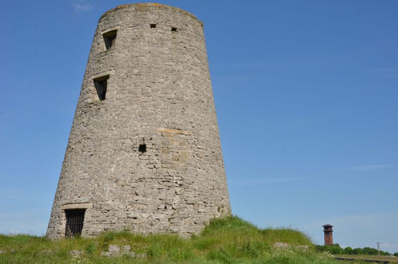
Entry Name: Cleadon Mill and Surrounding Wall
Listing Date: 26 February 1985
Grade: II
Source: Historic England
Source ID: 1025192
English Heritage Legacy ID: 303730
ID on this website: 101025192
Location: Cleadon, South Tyneside, Tyne and Wear, NE34
County: South Tyneside
Electoral Ward/Division: Cleadon and East Boldon
Parish: Non Civil Parish
Traditional County: Durham
Lieutenancy Area (Ceremonial County): Tyne and Wear
Church of England Parish: Cleadon All Saints
Church of England Diocese: Durham
Tagged with: Building
NZ 36SE BOLDON SUNNISIDE LANE
Cleadon
3/70 Cleadon Mill and
surrounding wall
GV II
Tower mill. Early C19. Limestone rubble, coursed. 3 storeys; north and south
entrances, 2 small square windows over, all empty; low retaining wall 2 metres
outside all round. Cap and sails removed. Derelict at time of survey.
Listing NGR: NZ3892663192
External links are from the relevant listing authority and, where applicable, Wikidata. Wikidata IDs may be related buildings as well as this specific building. If you want to add or update a link, you will need to do so by editing the Wikidata entry.


Other nearby listed buildings
