Approximate Location Map
Large Map »
Latitude: 51.068 / 51°4'4"N
Longitude: 0.6871 / 0°41'13"E
OS Eastings: 588364
OS Northings: 133292
OS Grid: TQ883332
Mapcode National: GBR QW3.SNF
Mapcode Global: FRA D6B9.7JB
Plus Code: 9F323M9P+6R
Entry Name: 49, High Street
Listing Date: 8 April 1970
Grade: II
Source: Historic England
Source ID: 1025851
English Heritage Legacy ID: 179723
ID on this website: 101025851
Location: Tenterden, Ashford, Kent, TN30
County: Kent
District: Ashford
Civil Parish: Tenterden
Built-Up Area: Tenterden
Traditional County: Kent
Lieutenancy Area (Ceremonial County): Kent
Tagged with: Building
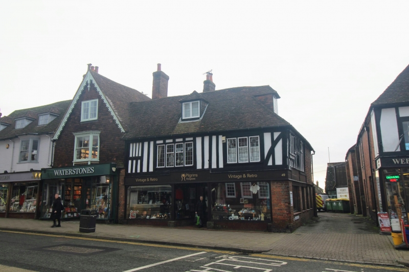
1.
1715 HIGH STREET
(South Side)
No 49
TQ 8833 1/185 8.4.70.
II GV
2.
A C15 to C16 timber-framed house. 2 storeys. 1st floor is closestudded
with plaster infill. Ground floor red brick. Hipped tiled roof with
1 hipped dormer. 2 modern casements with leaded lights on 1st floor and
later shopfront. The left side 1st floor has an original window opening,
now blocked.
All the listed buildings on the South side from Nos 17 to 57 form a group.
Listing NGR: TQ8836433292
External links are from the relevant listing authority and, where applicable, Wikidata. Wikidata IDs may be related buildings as well as this specific building. If you want to add or update a link, you will need to do so by editing the Wikidata entry.


Other nearby listed buildings
