Approximate Location Map
Large Map »
Latitude: 50.879 / 50°52'44"N
Longitude: -0.6937 / 0°41'37"W
OS Eastings: 491999
OS Northings: 109642
OS Grid: SU919096
Mapcode National: GBR DG9.ZBK
Mapcode Global: FRA 96FS.9KM
Plus Code: 9C2XV8H4+HG
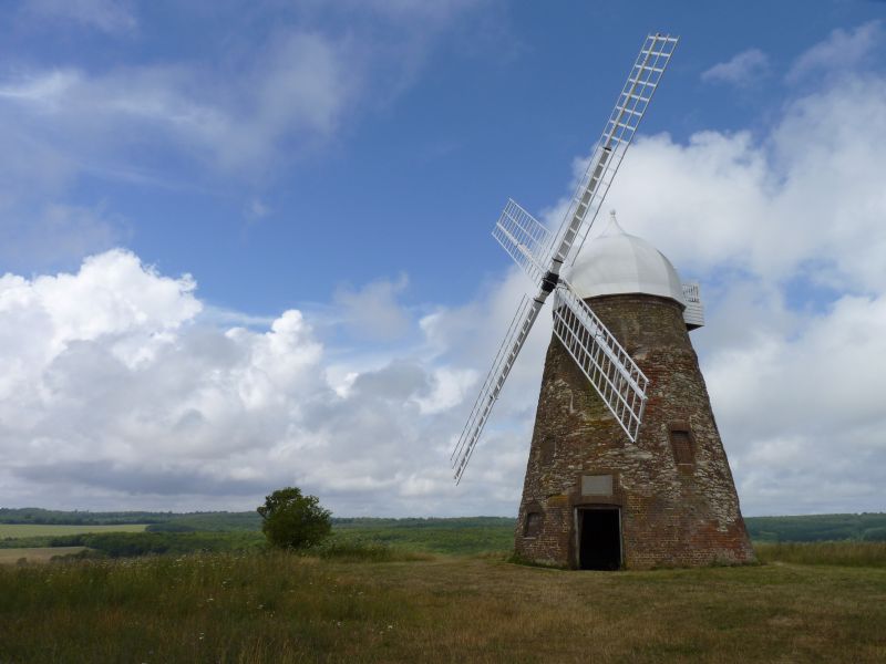
Entry Name: Halnaker Windmill
Listing Date: 5 June 1958
Grade: II
Source: Historic England
Source ID: 1026409
English Heritage Legacy ID: 300706
ID on this website: 101026409
Location: Chichester, West Sussex, PO18
County: West Sussex
District: Chichester
Civil Parish: Boxgrove
Traditional County: Sussex
Lieutenancy Area (Ceremonial County): West Sussex
Church of England Parish: Boxgrove
Church of England Diocese: Chichester
Tagged with: Tower mill
BOXGROVE PETWORTH ROAD, (north west side)
SU 90 NW HALNAKER
14/61 Halnaker Windmill
5.6.58
- II
A prominent landmark. Built in 1740. Restored from a complete ruin in 1934.
Tower type but lower than most tower mills. Red brick, covered with a thin
coating of burnt Sussex tiles. Octagonal cap of beehive shape, made of
sheets of metal, with finial. Sweeps intact. Fantail missing. The mill is
only a shell with no internal floors or machinery.
Listing NGR: SU9199909642
External links are from the relevant listing authority and, where applicable, Wikidata. Wikidata IDs may be related buildings as well as this specific building. If you want to add or update a link, you will need to do so by editing the Wikidata entry.


Other nearby listed buildings
