Approximate Location Map
Large Map »
Latitude: 50.8653 / 50°51'54"N
Longitude: -0.7124 / 0°42'44"W
OS Eastings: 490710
OS Northings: 108095
OS Grid: SU907080
Mapcode National: GBR DGH.LQG
Mapcode Global: FRA 96DT.898
Plus Code: 9C2XV78Q+42
Entry Name: South East Gateway to the Goodwood Estate, Adjoining Park Lane
Listing Date: 28 January 1986
Grade: II
Source: Historic England
Source ID: 1026441
English Heritage Legacy ID: 300689
ID on this website: 101026441
Location: Halnaker, Chichester, West Sussex, PO18
County: West Sussex
District: Chichester
Civil Parish: Boxgrove
Traditional County: Sussex
Lieutenancy Area (Ceremonial County): West Sussex
Church of England Parish: Boxgrove
Church of England Diocese: Chichester
Tagged with: Building
SU 90 NW
14/47
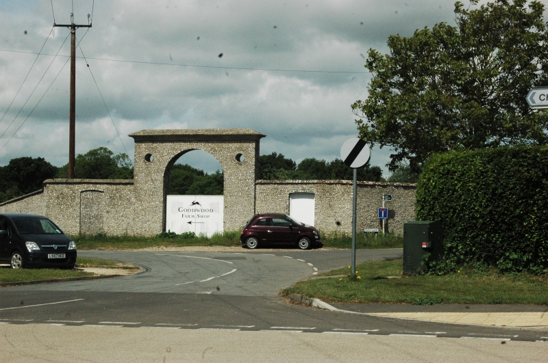
BOXGROVE, GOODWOOD ESTATE
South East Gateway to the Goodwood Estate, adjoining Park Lane
II
Early C19. Round-headed carriage archway of flints set in galletting with
cove over and tiled coping. Circular holes in the spandrels.
The Gates described do not give entrance to Goodwood Park but to a part of
the Estate which is in agricultural use, including the Home Farm. The road
to which they lead has no name.
Listing NGR: SU9071008095
External links are from the relevant listing authority and, where applicable, Wikidata. Wikidata IDs may be related buildings as well as this specific building. If you want to add or update a link, you will need to do so by editing the Wikidata entry.


Other nearby listed buildings
