Approximate Location Map
Large Map »
Latitude: 50.8554 / 50°51'19"N
Longitude: -0.5568 / 0°33'24"W
OS Eastings: 501681
OS Northings: 107206
OS Grid: TQ016072
Mapcode National: GBR FJ6.B1M
Mapcode Global: FRA 96QV.2WQ
Plus Code: 9C2XVC4V+57
Entry Name: The Priory (St Wilfred's)
Listing Date: 7 October 1974
Grade: II*
Source: Historic England
Source ID: 1027913
English Heritage Legacy ID: 297208
ID on this website: 101027913
Location: Arundel, Arun, West Sussex, BN18
County: West Sussex
District: Arun
Civil Parish: Arundel
Built-Up Area: Arundel
Traditional County: Sussex
Lieutenancy Area (Ceremonial County): West Sussex
Church of England Parish: Arundel St Nicholas with Tortington
Church of England Diocese: Chichester
Tagged with: Architectural structure
This list entry was subject to a Minor Amendment on 14/01/2013
TQ 0107
1/4
LONDON ROAD (North Side)
The Priory (St Wilfred's)
II*
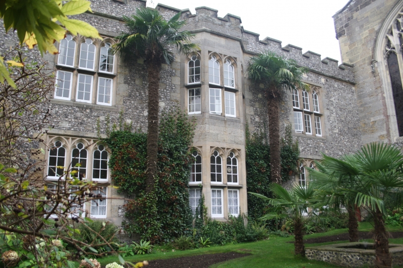
1380. Rebuilt in early C19 [not marked on 1785 map, therefore presumably ruinous at this date. Appears in present form on engraving by T Allom, d.1842]. Former College of Holy Trinity, attached to, and contemporary with the Fitzalan Chapel. Dissolved at Reformation, abandoned, then re-established in C19 as convent of Servite Nuns . Now an orphanage.
Nodular flint. Pulborough stone dressings in medieval parts, and some early C19 parts. Ashlar dressings elsewhere. Some random Pulborough stone, upper greensand, and clunch in medieval parts.
2 storeys. Crenellated parapet (machicolated on west elevation of south range). 2 ranges, set at 90 degrees, and 1 C14 wall to another, non-existent range, thus forming 3 sides of a courtyard of which the 4th is the south wall of the Fitzalan Chapel.
South elevation of south range has low tower at west end. 13 ranges of 2-light, cusped, pointed arched casement windows with diagonal lead glazing bars, set in oblong surrounds with moulded reveals. 2 doors with pointed arched heads set in oblong panels with moulded reveals, and with steps up flanked by iron railings with urn finials. 2 buttresses. West elevation of south range has 1 range of 4-light, cusped pointed arched windows set in square recessed panels with moulded reveals, and 4 quatrefoil panels between storeys. 1 door. C14 wall is pierced by unglazed 2-light windows with cusped trefoil heads, and embrasures splayed internally.
Listing NGR: TQ0168607208
External links are from the relevant listing authority and, where applicable, Wikidata. Wikidata IDs may be related buildings as well as this specific building. If you want to add or update a link, you will need to do so by editing the Wikidata entry.


Other nearby listed buildings
