Latitude: 52.3106 / 52°18'38"N
Longitude: 1.3664 / 1°21'59"E
OS Eastings: 629573
OS Northings: 273391
OS Grid: TM295733
Mapcode National: GBR WMQ.489
Mapcode Global: VHL9R.M6Q1
Plus Code: 9F438968+6H
Entry Name: Stadhaugh Manor Farmhouse
Listing Date: 29 July 1955
Grade: II
Source: Historic England
Source ID: 1032872
English Heritage Legacy ID: 280154
ID on this website: 101032872
Location: Laxfield, Mid Suffolk, IP13
County: Suffolk
District: Mid Suffolk
Civil Parish: Laxfield
Traditional County: Suffolk
Lieutenancy Area (Ceremonial County): Suffolk
Church of England Parish: Laxfield All Saints
Church of England Diocese: St.Edmundsbury and Ipswich
Tagged with: Farmhouse
LAXFIELD BANYARD'S GREEN
TM 27 SE
4/34 Stadhaugh Manor Farmhouse
-
29.7.55
-- II
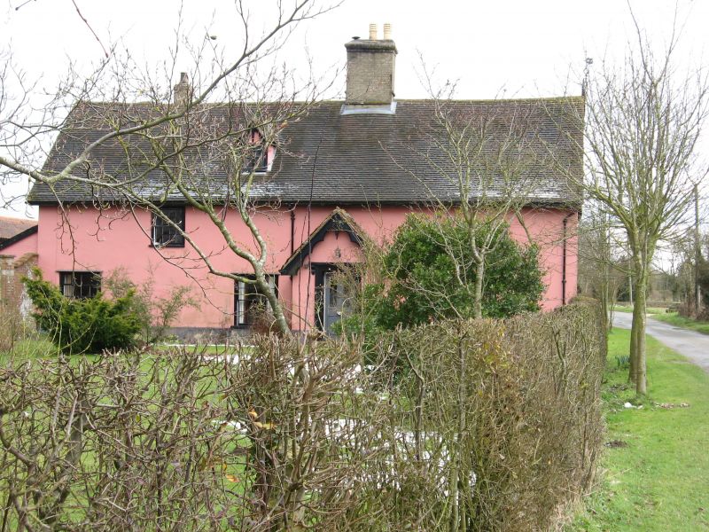
Farmhouse. Mid C16 with slightly later wing to rear forming L-shape plan.
Restored 1867 and again early C20. Timber framed and plastered, partly lined
to imitate ashlar. Plaintiled roof with crest tiles. Scalloped bargeboards
to all gables. 2 storeys and attic. 3-cell main range. 3 windows to ground
floor, 2 small-paned sashes and a matching casement window; one sash window
only to first floor. Lobby entrance: mid C19 porch, the door with 2 glazed
upper panels; moulded architrave and cornice, probably of stone. One gabled
dormer. Internal stack rebuilt in white brick. Above the road gable a C19
wind vane with the date 1602. Rear range has mainly old casement windows.
Front range considerably modernised internally. Moulded bridging beam in
hall. Also in the hall a good early C17 overmantel with elaborate carving,
including flowers enclosed by guilloche work. More of the structure is
visible in the rear range: a first floor ceiling with moulded joists and a
blocked window with moulded square mullions. The end portion of this range
has been lost. Roof over main range has clasped purlins, over rear range
clasped and butt purlins, both roofs with arched wind-bracing. In 1718 John
Smith left the property to the parish for the purpose of endowing a school, in
whose ownership it remained until c.1950. Remains of medieval moat.
Listing NGR: TM2957373391
External links are from the relevant listing authority and, where applicable, Wikidata. Wikidata IDs may be related buildings as well as this specific building. If you want to add or update a link, you will need to do so by editing the Wikidata entry.


Other nearby listed buildings