Approximate Location Map
Large Map »
Latitude: 51.2693 / 51°16'9"N
Longitude: -1.8027 / 1°48'9"W
OS Eastings: 413859
OS Northings: 152261
OS Grid: SU138522
Mapcode National: GBR 4YX.720
Mapcode Global: VHB4Y.PCV8
Plus Code: 9C3W759W+PW
Entry Name: Gate Piers to South Drive of Chisenbury Priory
Listing Date: 3 June 1986
Grade: II
Source: Historic England
Source ID: 1033968
English Heritage Legacy ID: 310969
ID on this website: 101033968
Location: East Chisenbury, Wiltshire, SN9
County: Wiltshire
Civil Parish: Enford
Traditional County: Wiltshire
Lieutenancy Area (Ceremonial County): Wiltshire
Church of England Parish: Enford All Saints
Church of England Diocese: Salisbury
Tagged with: Gatepost
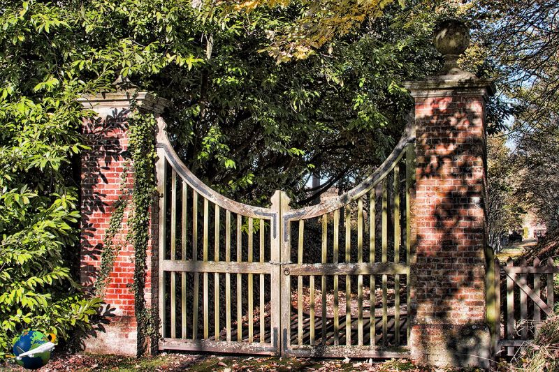
ENFORD EAST CHISENBURY
SU 15 SW (east side)
5/17 Gate piers to south drive of
Chisenbury Priory
II
Gate piers, 1923. Brick. 80cm shafts 4m high approximately, with
moulded stone cornice and ball finials, supporting timber gates of
open diamond staves and curved headrail. Iron brackets to joints.
C18 style.
Listing NGR: SU1385952261
External links are from the relevant listing authority and, where applicable, Wikidata. Wikidata IDs may be related buildings as well as this specific building. If you want to add or update a link, you will need to do so by editing the Wikidata entry.


Other nearby listed buildings
