Approximate Location Map
Large Map »
Latitude: 51.421 / 51°25'15"N
Longitude: -1.7265 / 1°43'35"W
OS Eastings: 419111
OS Northings: 169145
OS Grid: SU191691
Mapcode National: GBR 4X2.VQC
Mapcode Global: VHC1P.1K30
Plus Code: 9C3WC7CF+C9
Entry Name: 6, London Road
Listing Date: 21 October 1974
Grade: II
Source: Historic England
Source ID: 1034204
English Heritage Legacy ID: 310422
ID on this website: 101034204
Location: Marlborough, Wiltshire, SN8
County: Wiltshire
Civil Parish: Marlborough
Built-Up Area: Marlborough
Traditional County: Wiltshire
Lieutenancy Area (Ceremonial County): Wiltshire
Tagged with: Building
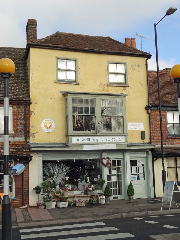
LONDON ROAD
1.
5407
(East Side)
No 6
SU 1969 1/222
II GV
2.
C18. Rendered. Hipped old tile roof. Chequer brick stack. 3 storeys. 2 cased
sashes with glazing bars in moulded frames on 2nd floor. 1 Cl9 oblong oriel
with sashes and glazing bars on lst floor. C19 shop front.
Nos 3 to 7 (consec) form a group.
Listing NGR: SU1911169145
External links are from the relevant listing authority and, where applicable, Wikidata. Wikidata IDs may be related buildings as well as this specific building. If you want to add or update a link, you will need to do so by editing the Wikidata entry.


Other nearby listed buildings
