Approximate Location Map
Large Map »
Latitude: 51.4224 / 51°25'20"N
Longitude: -1.7273 / 1°43'38"W
OS Eastings: 419059
OS Northings: 169301
OS Grid: SU190693
Mapcode National: GBR 4X2.N4B
Mapcode Global: VHC1P.0HQY
Plus Code: 9C3WC7CF+X3
Entry Name: 10, the Green
Listing Date: 18 July 1949
Last Amended: 21 October 1974
Grade: II
Source: Historic England
Source ID: 1034279
English Heritage Legacy ID: 310295
ID on this website: 101034279
Location: Marlborough, Wiltshire, SN8
County: Wiltshire
Civil Parish: Marlborough
Built-Up Area: Marlborough
Traditional County: Wiltshire
Lieutenancy Area (Ceremonial County): Wiltshire
Tagged with: Building
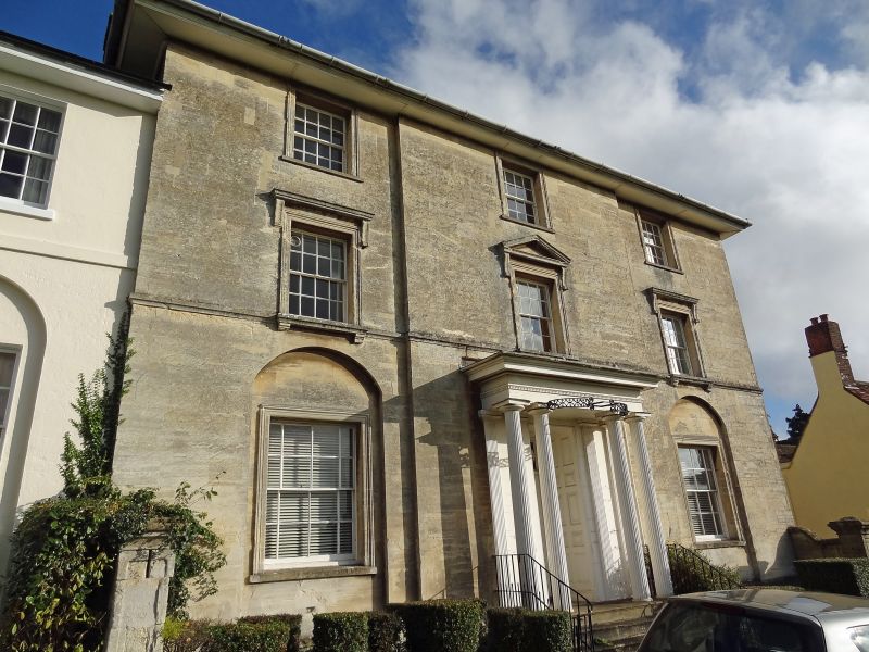
THE GREEN
1.
5407
(East Side)
No 10
SU 1969 1/76 18.7.49
II GV
2.
Early C19 front to older building. 3 storey. Ashlar bath stone. Projecting plinth,
moulded string at 1st floor cill level. Wide boxed caves. Hipped slate roof.
3 windows to upper floors, with moulded cornices to 1st floor and pediment to central
1st floor window. Two ground floor windows with moulded architrave surrounds set
in 4 centred arches, springing from plinth. Tall 8 panel central door with rectangular
fanlight of oval and curved diamond pattern in deep recess with double panelled
reveal (10 panels to each side and 4 to soffit). Wide stone porch with 4 fluted
Greek Doric columns and 4 fluted pilasters on wall face, with Greek Doric entablature.
Later C19 rails on top of porch. Good early C19 lampholder fixed to caps of 2
centre columns, 5 moulded stone steps, and plain bar guard rails. Flanking screen
walls with panelled piers. South front has a panel on each floor to lefthand -
arched stair window and door under with flat hood, earlier building to righthand
with 2 storey segmental bay of 3 windows.
Nos 8 to 16 (consec) form a group.
Listing NGR: SU1905969306
External links are from the relevant listing authority and, where applicable, Wikidata. Wikidata IDs may be related buildings as well as this specific building. If you want to add or update a link, you will need to do so by editing the Wikidata entry.


Other nearby listed buildings
