Latitude: 50.6999 / 50°41'59"N
Longitude: -1.2956 / 1°17'44"W
OS Eastings: 449844
OS Northings: 89159
OS Grid: SZ498891
Mapcode National: GBR 8BJ.37V
Mapcode Global: FRA 8757.92J
Plus Code: 9C2WMPX3+XQ
Entry Name: 114 High Street and 18 St James’s Street
Listing Date: 1 February 1972
Last Amended: 1 August 2024
Grade: II
Source: Historic England
Source ID: 1034582
English Heritage Legacy ID: 309555
ID on this website: 101034582
Location: Newport, Isle of Wight, PO30
County: Isle of Wight
Civil Parish: Newport
Built-Up Area: Newport
Traditional County: Hampshire
Lieutenancy Area (Ceremonial County): Isle of Wight
Church of England Parish: Newport St Thomas
Church of England Diocese: Portsmouth
Tagged with: Building
Townhouse with shop, built in the early C19, with a mid-C19 shopfront.
Townhouse with shop, built in the early C19, with a mid-C19 shopfront.
MATERIALS: the building is constructed of brick laid in a checker pattern, with red brick dressings including window surrounds and quoins. It is topped by a hipped slate roof
PLAN: a roughly rectangular building on a corner plot with the south and west elevations facing High Street and St James's Street respectively.
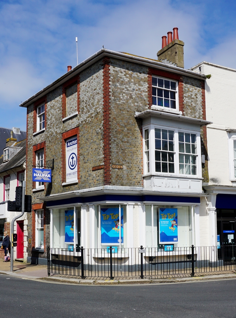
EXTERIOR: the building is three storeys. The ground floor includes a mid-C19 shopfront with a rectangular box window on each side, consisting of a narrow box window on the canted corner (late-C20 replacement), and two large box windows to the south and west. Each window is flanked by Doric pilasters supporting a frieze and cornice. Also, on the west elevation is a ground-floor sash window with glazing bars to the upper sash.
On the first floor, the south elevation includes a rectangular bay window consisting of four lights; two six-over-six sashes to the front, and two-over-two sashes in the returns. The sashes are divided by plain strips, there is a panelled apron, and the bay is topped by a plain frieze, and shallow projecting moulded cornice. There are also two windows on the west elevation, one a shallow recess and the other a six-over-six sash.
On the second floor there is a three-over-six sash to the south, and to the west is a matching sash and a further shallow recess. The windows are all in recessed openings and topped by splayed-brick flat arches; the top floor arches are narrower. Below the hipped roof is a timber-eaves cornice.
Newport's first charter was granted by Richard de Redvers, fourth Earl of Devon in the late C12 and this is generally regarded as marking its foundation. The settlement was laid out on the low-lying ground along the western bank of the River Medina using a grid-style plan. Recent topographic analysis suggests that Newport may have developed around an existing informal trading settlement located at the head of Medina estuary, in the vicinity of Sea and Quay Street (Alexander, 2021). The High Street is one of five east-west running streets within the grid layout. High Street and Pyle Street extend the full length of the grid, divided by a market square, and form the planned core of Newport, with other shorter parallel streets to the south (South Street) and north (Lugley and Crocker Street). They were all largely in place by the mid-C13.
In the C14, the Isle of Wight was frequently subject to raids by French forces during long-running conflicts between England and France. According to historical documents, during one of the raids in 1377 Newport was severely damaged by fire and much of the population fled to Carisbrooke Castle. It appears that Newport was functioning again a few years later. During this century, records indicate that the population of Newport did decrease, most likely due to several wider economic factors, and did not significantly increase until the mid-C17. The town was incorporated as a borough in 1608 under a new charter granted by James I. Newport did not significantly expand beyond its medieval limits until around the late C18. By the mid-C19 there had been a more significant expansion of the town, including the development of its suburbs, which continued into the C20.
Number 114 was built in the early C19. The building appears on the First Edition Ordnance Survey map (1864; 1:2500) shown as a corner plot with a rectangular footprint. By the early C20 numbers 114 and 115 had been amalgamated and occupied by a grocers, wine and spirit merchants. In the mid-C20 the occupancy of the buildings had separated with 114 continuing to be used by a wine merchant. In 1972 the ground floor was described as having box windows on each side. A 1980s photograph shows the ground floor corner elevation including an entrance door. By the end of the C20, the doorway had been replaced by a box window in the same style as the other shop windows. Also, by this time the ground floor of 114 and 115 had been combined again. The first floor of number 114 is accessed by a door in number 18 St James's Street (Grade II; National Heritage List for England entry 1034517).
External links are from the relevant listing authority and, where applicable, Wikidata. Wikidata IDs may be related buildings as well as this specific building. If you want to add or update a link, you will need to do so by editing the Wikidata entry.


Other nearby listed buildings