Approximate Location Map
Large Map »
Latitude: 52.2819 / 52°16'54"N
Longitude: -1.5884 / 1°35'18"W
OS Eastings: 428176
OS Northings: 264937
OS Grid: SP281649
Mapcode National: GBR 5M4.TGZ
Mapcode Global: VHBXH.FX43
Plus Code: 9C4W7CJ6+PJ
Entry Name: 19, Church Street
Listing Date: 19 March 1973
Grade: II
Source: Historic England
Source ID: 1035494
English Heritage Legacy ID: 307430
ID on this website: 101035494
Location: Warwick, Warwickshire, CV34
County: Warwickshire
District: Warwick
Civil Parish: Warwick
Built-Up Area: Warwick
Traditional County: Warwickshire
Lieutenancy Area (Ceremonial County): Warwickshire
Church of England Parish: Warwick St Mary
Church of England Diocese: Coventry
Tagged with: Building
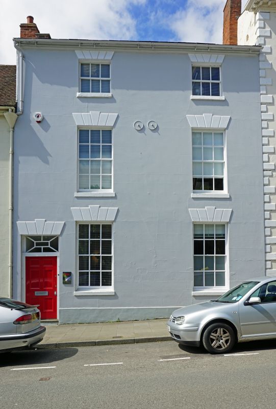
1.
1781 CHURCH STREET
(West Side)
No 19
SP 2864 NW 1/27
II GV
2.
Early C19. Stucco Welsh slates. 3 storeys, plinth cornice. 2 sashes
with glazing bars in reveals under rusticated heads. 6 panel door on left
under oblong fanlight with ornamental glazing bars, rusticated head and
keyblock.
All the listed buildings in Church Street (West Side) form a group.
Listing NGR: SP2817664937
External links are from the relevant listing authority and, where applicable, Wikidata. Wikidata IDs may be related buildings as well as this specific building. If you want to add or update a link, you will need to do so by editing the Wikidata entry.


Other nearby listed buildings
