Approximate Location Map
Large Map »
Latitude: 52.6286 / 52°37'43"N
Longitude: -2.4779 / 2°28'40"W
OS Eastings: 367750
OS Northings: 303537
OS Grid: SJ677035
Mapcode National: GBR BW.7JPB
Mapcode Global: WH9DG.X675
Plus Code: 9C4VJGHC+FR
Entry Name: 24, Belmont Road
Listing Date: 8 April 1983
Grade: II
Source: Historic England
Source ID: 1038631
English Heritage Legacy ID: 362133
ID on this website: 101038631
Location: Ironbridge, Telford and Wrekin, Shropshire, TF8
County: Telford and Wrekin
Civil Parish: The Gorge
Built-Up Area: Telford
Traditional County: Shropshire
Lieutenancy Area (Ceremonial County): Shropshire
Church of England Parish: Ironbridge
Church of England Diocese: Hereford
Tagged with: Building
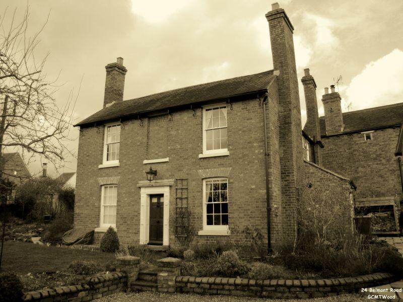
IRONBRIDGE BELMONT ROAD
1.
5362 (north side)
No 24
14/268
II GV
2.
Early C19 buff brick house. Plain tile roof with gabled ends. Two storeys. Three
bays. Sashes with glazing bars, centre first floor blind, ground floor segmental
brick arches. Central pilastered doorcase and glazed door. Brick end stacks.
Listing NGR: SJ6775003537
External links are from the relevant listing authority and, where applicable, Wikidata. Wikidata IDs may be related buildings as well as this specific building. If you want to add or update a link, you will need to do so by editing the Wikidata entry.


Other nearby listed buildings
