Approximate Location Map
Large Map »
Latitude: 52.6546 / 52°39'16"N
Longitude: -1.816 / 1°48'57"W
OS Eastings: 412545
OS Northings: 306334
OS Grid: SK125063
Mapcode National: GBR 4F1.HPT
Mapcode Global: WHCGW.2JJS
Plus Code: 9C4WM53M+RJ
Entry Name: Whitehouse Farmhouse
Listing Date: 15 January 1988
Grade: II
Source: Historic England
Source ID: 1038839
English Heritage Legacy ID: 272717
ID on this website: 101038839
Location: Lichfield, Staffordshire, WS14
County: Staffordshire
District: Lichfield
Civil Parish: Swinfen and Packington
Traditional County: Staffordshire
Lieutenancy Area (Ceremonial County): Staffordshire
Church of England Parish: Weeford St Mary the Virgin
Church of England Diocese: Lichfield
Tagged with: Farmhouse
SK 10 NW SWINFEN AND
PACKINGTON C.P.
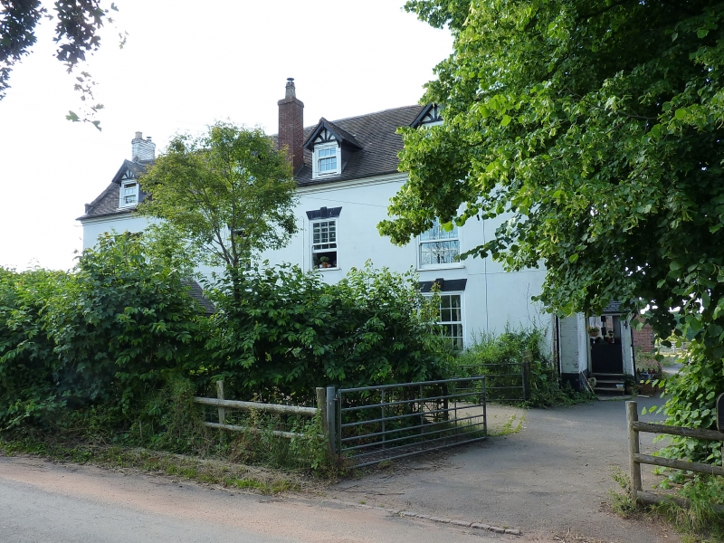
6/101 Whitehouse Farmhouse
II
Farmhouse. Mid C18 with early and later C19 alterations. Rendered
brickwork; tiled roof; end stacks and ridge stack to left of centre.
Two storeys and dormer lit attic. 1+3 window front widely spaced
(probably an added bay) to left; glazing bar sashes with wedged and
keystone heads of sixteen panes to left bay and with a transomed casement
to ground floor right. Each range of windows has a gabled dormer
over. Entrance to left of centre set in a C20 gabled porch.
Listing NGR: SK1254506334
External links are from the relevant listing authority and, where applicable, Wikidata. Wikidata IDs may be related buildings as well as this specific building. If you want to add or update a link, you will need to do so by editing the Wikidata entry.


Other nearby listed buildings
