Approximate Location Map
Large Map »
Latitude: 52.6831 / 52°40'59"N
Longitude: -2.0691 / 2°4'8"W
OS Eastings: 395423
OS Northings: 309491
OS Grid: SJ954094
Mapcode National: GBR 29N.RPX
Mapcode Global: WHBFF.5TYF
Plus Code: 9C4VMWMJ+68
Entry Name: The Four Crosses Inn
Listing Date: 16 May 1953
Grade: II
Source: Historic England
Source ID: 1039173
English Heritage Legacy ID: 271778
ID on this website: 101039173
Location: Four Crosses, South Staffordshire, WS11
County: Staffordshire
District: South Staffordshire
Civil Parish: Hatherton
Traditional County: Staffordshire
Lieutenancy Area (Ceremonial County): Staffordshire
Church of England Parish: Hatherton St Saviour
Church of England Diocese: Lichfield
Tagged with: Inn
SJ 90 NE
4/10
HATHERTON
WATLING STREET (south side)
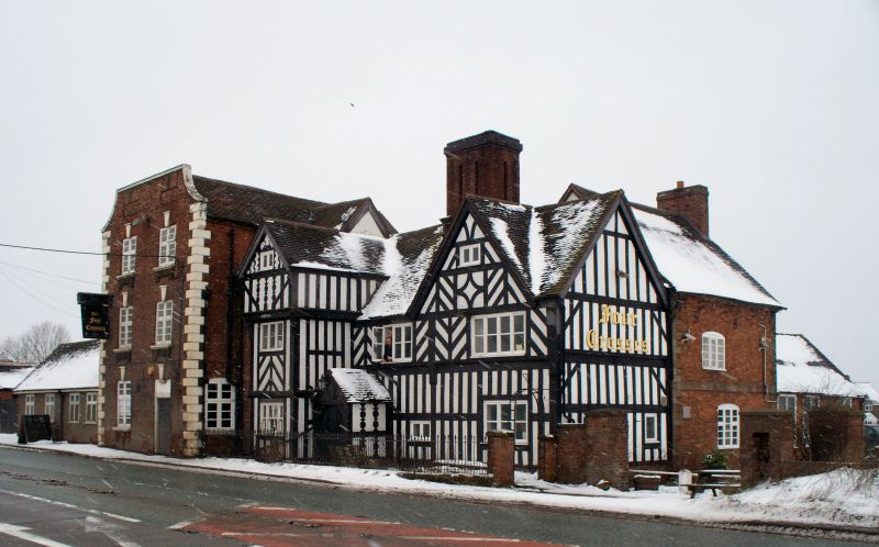
The Four Crosses Inn
16.5.53
II
Inn. Dated 1636, extended circa 1700 and in the mid-C18 restored 1925. C17 timber framing of close studding with middle rail and diagonal braces in herringbone patterns. Red brick extension; plain tile roofs; brick ridge stack. L-shaped building of 1636; main range aligned east-west facing north with crosswing to the east projecting north, and porch in the re-entrant angle between the two buildings. Extension block of two parallel ranges to the case aligned north-south; mid-C18 rear extension wing to the west. Building of 1636 to the right, extension of circa 1700 to the left.
Building of 1636: two storeys and attic, three window front. Full height gabled porch to left with jettied upper floors, diagonally placed angle brackets, and balusters beneath the attic window. The attic bresummer is inscribed "1636 N / 1 E" and a rail over the ground floor window is inscribed "NERES SISCIRES UNUM TUA TEMPORA MESEM RIDES CUN NON SIT FORSITAN UNA DIES". Single-storey C20 gabled porch in the angle between the C17 porch and main range.
Extension of circa 1700. Three storeys with quoins of unequal length and a coped parapet ramped down at the ends containing blind panels over the windows. Two windows, C19 and C20 casements with gauged brick heads, raised keystones and aprons. To the left on the first floor a C20 wooden sign board suspended from a cantilevered beam. Six-panel door to the right, set within a former window opening. Mid-C18 brick rear wing of two storeys with ashlar quoins of unequal length and ashlar storey band; casement windows with segmental heads.
Interior. Chamfered and stopped ceiling beams.
Listing NGR: SJ9542309491
External links are from the relevant listing authority and, where applicable, Wikidata. Wikidata IDs may be related buildings as well as this specific building. If you want to add or update a link, you will need to do so by editing the Wikidata entry.


Other nearby listed buildings
