Approximate Location Map
Large Map »
Latitude: 53.0688 / 53°4'7"N
Longitude: -2.517 / 2°31'1"W
OS Eastings: 365457
OS Northings: 352524
OS Grid: SJ654525
Mapcode National: GBR 7T.BM3W
Mapcode Global: WH9BB.94P6
Plus Code: 9C5V3F9M+G6
Entry Name: Wright's Almshouses
Listing Date: 19 April 1948
Last Amended: 5 May 1976
Grade: II*
Source: Historic England
Source ID: 1039555
English Heritage Legacy ID: 431237
ID on this website: 101039555
Location: Nantwich, Cheshire East, Cheshire, CW5
County: Cheshire East
Civil Parish: Nantwich
Built-Up Area: Nantwich
Traditional County: Cheshire
Lieutenancy Area (Ceremonial County): Cheshire
Church of England Parish: Nantwich St Mary
Church of England Diocese: Chester
Tagged with: Almshouse
1.
1425 LONDON ROAD
-----------
Nos 8 to 18 (even)
SJ 6552 1/63 19.4.48 (Wright's Almshouses)
II*
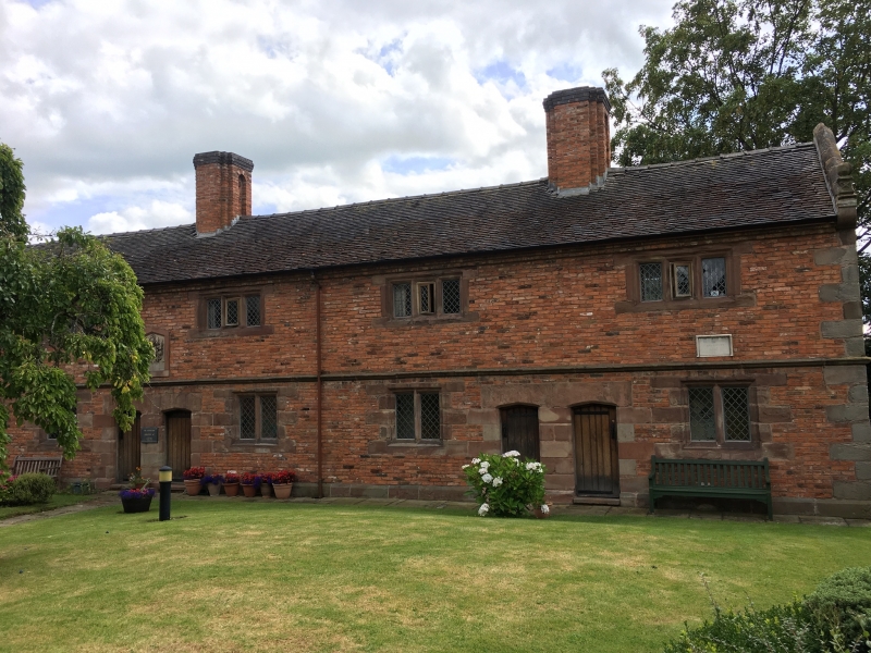
2.
Built 1658 by Sir Edmund Wright (Lord Mayor of London 1641). A block of 6 cottages;
2 storeys; brick with stone long and short quoins; moulded string course, quoined
window and door surrounds; gable copings with ball feet; 6 iron casement windows
----------------------------------------------
1.
l425 LONDON ROAD
-----------
Nos 8 to l8 (even)
(Wright's Almshouses)
SJ 6552 1/63 19.4.48.
II*
2. _
Built 1638 by Sir Edmund Wright (Lord Mayor of London 1641). A block of 6 cottages;
2 storeys; brick with stone long and short quoins; moulded string course; quoined
window and door surrounds; gable copings with ball feet; 6 iron casement windows
with stone mullions and jambs and restored leaded lights (many now broken); 6
battern doors with moulded joints, restored; old tiled roof; good brick stacks.
Carved centre stone panel with arms and partly defaced inscription.
Unoccupied and in urgent need of repair when inspected but it is proposed to
dismantle the building and re-erect it by Crewe's Almshouses in Beam Street (Map
No l/66)
Listing NGR: SJ6545752524
External links are from the relevant listing authority and, where applicable, Wikidata. Wikidata IDs may be related buildings as well as this specific building. If you want to add or update a link, you will need to do so by editing the Wikidata entry.


Other nearby listed buildings
