Approximate Location Map
Large Map »
Latitude: 52.3002 / 52°18'0"N
Longitude: -0.6923 / 0°41'32"W
OS Eastings: 489272
OS Northings: 267702
OS Grid: SP892677
Mapcode National: GBR CX2.RT5
Mapcode Global: VHDRW.YGD0
Plus Code: 9C4X8825+33
Entry Name: Tudor Restaurant
Listing Date: 23 September 1950
Last Amended: 12 March 1986
Grade: II
Source: Historic England
Source ID: 1040602
English Heritage Legacy ID: 233810
ID on this website: 101040602
Location: Wellingborough, North Northamptonshire, NN8
County: North Northamptonshire
Electoral Ward/Division: Swanspool
Parish: Non Civil Parish
Built-Up Area: Wellingborough
Traditional County: Northamptonshire
Lieutenancy Area (Ceremonial County): Northamptonshire
Church of England Parish: Wellingborough
Church of England Diocese: Peterborough
Tagged with: Building
SP8967NW
11/149
23/09/50
WELLINGBOROUGH
SHEEP STREET
(West side)
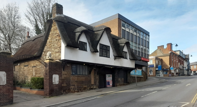
No.29 and 30 (Tudor Restaurant)
(Formerly listed as No.29 and 30)
GV
II
Two houses, now restaurant. Reputedly of medieval origin but mainly late C16,
restored early C20. Squared coursed ironstone and timber frame with thatch roof.
L-shape plan with central carriage arch. 2 storeys. Main front of 3-window
range. No.29 has part-glazed door with flight of steps and canted bay window
with stone base, to left. No.30 has a ribbed door with 2-light wooden casement
to left. Oversailing first floor is timber framed, now plastered. Central
first-floor window has arch headed centre light and is flanked by 2-light
casements; all with leaded lights. Central gable flanked by 2 smaller gables.
Rear wing is similar, all of stone. Interior: No.29 has a small open fireplace
with a bressumer and chamfered ceiling beams. Some original roof timbers may
remain.
(History of Wellingborough: J. and M. Palmer; Buildings of England:
Northamptonshire, p.456).
Listing NGR: SP8927267702
External links are from the relevant listing authority and, where applicable, Wikidata. Wikidata IDs may be related buildings as well as this specific building. If you want to add or update a link, you will need to do so by editing the Wikidata entry.


Other nearby listed buildings
