Latitude: 52.2637 / 52°15'49"N
Longitude: -0.7537 / 0°45'13"W
OS Eastings: 485154
OS Northings: 263568
OS Grid: SP851635
Mapcode National: GBR CXL.27Z
Mapcode Global: VHDS1.WCFH
Plus Code: 9C4X767W+FG
Entry Name: The Priory
Listing Date: 2 August 1972
Last Amended: 13 May 1986
Grade: II
Source: Historic England
Source ID: 1040804
English Heritage Legacy ID: 233305
ID on this website: 101040804
Location: Earls Barton, North Northamptonshire, NN6
County: North Northamptonshire
Civil Parish: Earls Barton
Built-Up Area: Earls Barton
Traditional County: Northamptonshire
Lieutenancy Area (Ceremonial County): Northamptonshire
Church of England Parish: Earls Barton All Saints
Church of England Diocese: Peterborough
Tagged with: Priory
EARLS BATON STATION ROAD
SP8563 (West side)
20/27 The Priory
02/08/72
- II
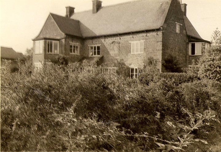
Farmhouse, now house. Late C17. Squared coursed lias with C19 plain-tile roof.
Originally 3-unit plan. 2 storeys. 3-window range of C19 casements under wood
lintels. C19 bay to left breaks forward with early C20 bay windows at gable end.
C20 door and lean-to porch to left of centre. Ashlar gable parapets and kneelers
and brick stacks at ridge and end. Large sundial c.1910 to right of centre. C18
wing to rear in similar style has early C20 bay window. Interior not inspected
but noted as having ceiling beams and panelled window reveals.
Listing NGR: SP8515463568
External links are from the relevant listing authority and, where applicable, Wikidata. Wikidata IDs may be related buildings as well as this specific building. If you want to add or update a link, you will need to do so by editing the Wikidata entry.


Other nearby listed buildings