Approximate Location Map
Large Map »
Latitude: 52.0827 / 52°4'57"N
Longitude: -0.8885 / 0°53'18"W
OS Eastings: 476259
OS Northings: 243286
OS Grid: SP762432
Mapcode National: GBR BY6.J5J
Mapcode Global: VHDSR.KX49
Plus Code: 9C4X34M6+3H
Entry Name: The Old Vicarage
Listing Date: 18 May 1988
Grade: II
Source: Historic England
Source ID: 1041648
English Heritage Legacy ID: 235331
ID on this website: 101041648
Location: Potterspury, West Northamptonshire, NN12
County: West Northamptonshire
Civil Parish: Potterspury
Built-Up Area: Potterspury
Traditional County: Northamptonshire
Lieutenancy Area (Ceremonial County): Northamptonshire
Church of England Parish: Potterspury with Furtho and Yardley Gobion
Church of England Diocese: Peterborough
Tagged with: Clergy house Thatched cottage
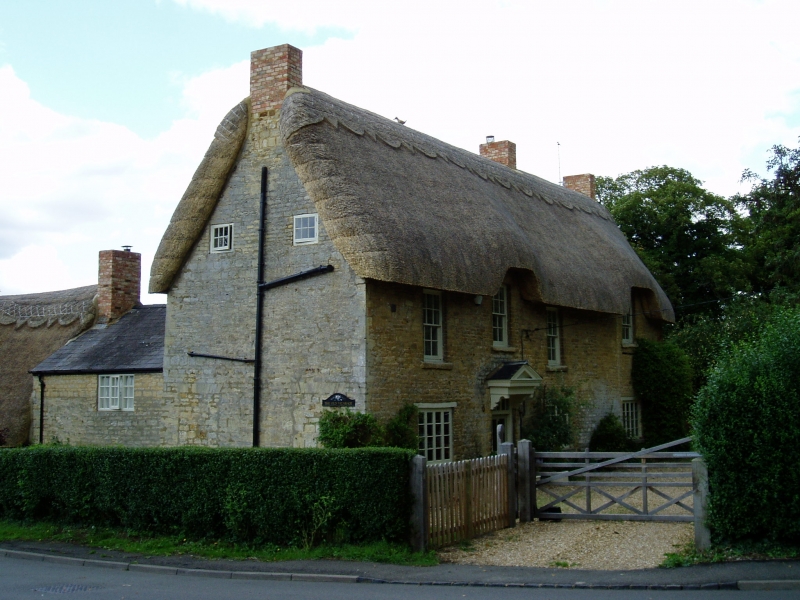
POTTERSPURY CHURCH END
SP7642 (East side)
15/94 The Old Vicarage
GV II
House, formerly vicarage. Late C17 extended C18 with C19 and C20 alterations.
Coursed limestone rubble, thatch roof, brick end and ridge stacks. 2 storeys and
attic. 4-window range. 2-unit plan with one-unit addition. 4-panelled
part-glazed door to left of centre with overlight and gabled hood on brackets,
supported by posts. 4-light casement windows to ground floor with wood lintels,
12-pane sash windows to 1st floor with wood lintels, except for that above door
with flat-arched head and in eyebrow dormer. Right end bay is an addition,
probably C18, 2-storey wing to rear left. Interior has ogee-stop-chamfered spine
beans. One open fireplace with chamfered bressumer, another open fireplace to
original kitchen with cambered chamfered bressumer. 3-bay roof to original core
has ties and collars to principal rafters, 2 tiers of purlins and ridge piece.
Listing NGR: SP7625943286
External links are from the relevant listing authority and, where applicable, Wikidata. Wikidata IDs may be related buildings as well as this specific building. If you want to add or update a link, you will need to do so by editing the Wikidata entry.


Other nearby listed buildings
