Approximate Location Map
Large Map »
Latitude: 55.1681 / 55°10'5"N
Longitude: -1.8601 / 1°51'36"W
OS Eastings: 409011
OS Northings: 585983
OS Grid: NZ090859
Mapcode National: GBR H8GP.36
Mapcode Global: WHC2N.DCHF
Plus Code: 9C7W549Q+6X
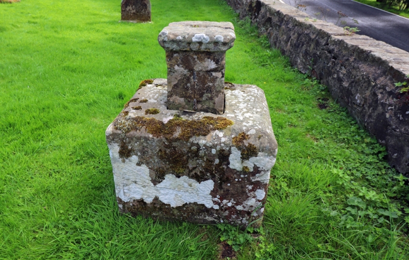
Entry Name: Sundial 3M East of South Gate of Churchyard of St Andrew
Listing Date: 30 January 1986
Grade: II
Source: Historic England
Source ID: 1042119
English Heritage Legacy ID: 238266
ID on this website: 101042119
Location: Hartburn, Northumberland, NE61
County: Northumberland
Civil Parish: Hartburn
Traditional County: Northumberland
Lieutenancy Area (Ceremonial County): Northumberland
Church of England Parish: Hartburn with Meldon
Church of England Diocese: Newcastle
Tagged with: Sundial
HARTBURN HART BURN
NZ 08 NE
9/27 Sundial 3m east of
south gate of churchyard
of St. Andrew
GV II
Sundial, 1720. Stone. Large square block with roll mould at corners and
chamfered top supports smaller block with ornamental margin and dated incised
sundial.
Listing NGR: NZ0901185983
External links are from the relevant listing authority and, where applicable, Wikidata. Wikidata IDs may be related buildings as well as this specific building. If you want to add or update a link, you will need to do so by editing the Wikidata entry.


Other nearby listed buildings
